Isolated Severe Storms Target St Louis Missouri and Surrounding Illinois Areas Tonight With Low Tornado Risk but Lightning and Gusty Winds Possible
ST. LOUIS, MISSOURI — A line of scattered thunderstorms is moving through parts of eastern Missouri and southwestern Illinois this evening, with the greatest chance for isolated severe activity centered near the St. Louis metro area.
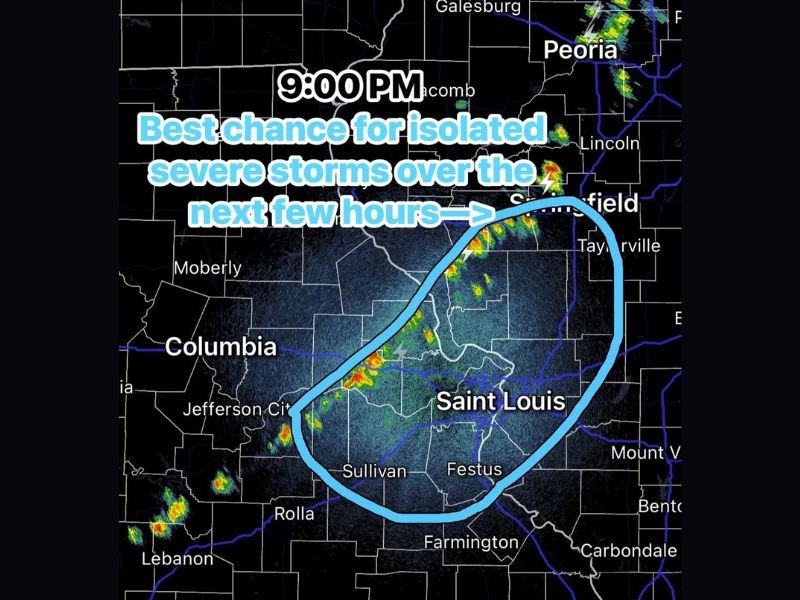
Radar imagery around 9:00 PM highlights a corridor from Sullivan, Missouri through St. Louis and into areas near Taylorville, Illinois as the primary zone where storms could briefly intensify.
Best Chance for Stronger Storms Focused Near St. Louis Corridor
The most favorable environment for isolated severe storms is currently aligned along and just east of the Mississippi River.
Communities including Sullivan, Festus, and the broader St. Louis region are within the highlighted area where storms may strengthen over the next few hours. Further northeast toward central Illinois, including areas near Taylorville, storms are also being monitored for possible intensification.
Low Tornado Risk but Some Storms Could Turn Strong
While atmospheric conditions support a limited severe weather setup, the tornado threat remains low. However, a few storms could still produce brief strong wind gusts, small hail, and frequent lightning as they move through the region. The setup suggests that any severe activity will remain isolated rather than widespread.
Storms Expected to Remain Scattered and Short-Lived
These storms are not expected to organize into a major severe weather event. Instead, activity will likely remain scattered, with individual cells strengthening briefly before weakening as they track northeast. This means some neighborhoods may see intense rain and lightning, while others nearby experience little to no impact.
Timing Window Focused Over the Next Few Hours
The primary window for any stronger storm activity is expected through the late evening hours. As the system continues moving northeast, conditions should gradually stabilize overnight, reducing the risk for additional strengthening. Residents are advised to stay alert for changing conditions, especially if storms approach their area.
Travel and Evening Plans May Be Briefly Impacted
Drivers in and around the St. Louis metro area could encounter sudden downpours, reduced visibility, and lightning. While widespread hazards are not expected, brief impacts could still disrupt evening commutes or outdoor plans. Staying weather-aware during passing storms remains important, even with a lower-end risk setup.
If you’re in Missouri or Illinois and seeing storms near your area tonight, share your conditions and stay updated with more local coverage on SaludaStandard-Sentinel.com.