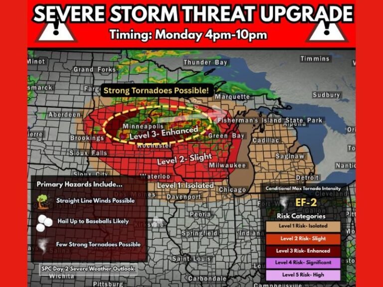
Iowa, Missouri, Illinois and Minnesota Facing Significant Severe Weather Tuesday With Numerous Strong Tornadoes and Very Large Hail Threatening the Region Tuesday Night
IOWA AND MISSOURI — A significant and potentially devastating severe weather event is locked in for Tuesday afternoon, evening, and overnight hours across portions of Iowa and Missouri, with severe weather extending further east and south into Illinois and beyond. Tuesday will likely be the most significant severe weather day of the entire upcoming week, and forecasters are warning that multiple days of dangerous weather require residents across the entire region to remain prepared and alert starting now.
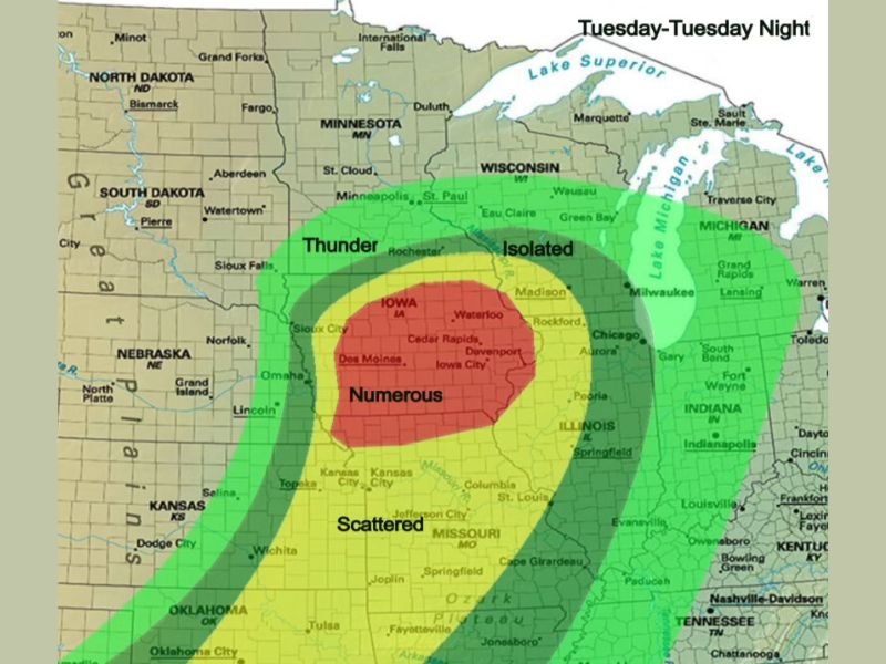
Iowa in the Bullseye With Numerous Severe Storms Expected
Iowa sits directly in the most dangerous zone on Tuesday’s severe weather outlook, with the outlook map showing a Numerous severe storm classification covering the heart of the state. Communities including Des Moines, Cedar Rapids, Waterloo, Davenport, Iowa City, and Sioux City are all within the highest risk corridor for Tuesday’s event.
Environmental conditions across Iowa are described as kinematically primed to support very large hail and strong tornadoes in any supercell that develops during the afternoon and evening hours. Initiation is expected near the triple point in central Iowa during the mid to late afternoon, with storms then racing east and northeast through the evening and overnight hours.
Strong Tornadoes and Very Large Hail Are the Primary Threats
The atmospheric setup for Tuesday across Iowa is not generating concern about run-of-the-mill severe weather. The kinematic environment, which refers to the wind shear and rotational energy available to developing supercells, is supportive of very large hail and strong tornadoes as the primary hazards during this event.
Any supercell that fires across Iowa during Tuesday afternoon has the potential to rapidly become a significant tornado-producing storm. Residents across the Numerous risk zone must treat Tuesday as a life-threatening severe weather day and have their shelter plans fully finalized before afternoon storm initiation begins.
Scattered and Thunder Risk Extends Into Missouri and Illinois
South of Iowa across Missouri, a Scattered severe weather risk covers communities including Kansas City, Columbia, St. Louis, Jefferson City, Springfield, and Cape Girardeau. Illinois communities including Chicago, Peoria, Springfield, and Rockford fall within the Thunder and Isolated risk zones extending east of the primary severe weather corridor.
While the threat decreases in intensity moving away from Iowa, isolated and scattered severe storms remain possible across Missouri and Illinois through Tuesday night.
Prepare Now Before Tuesday Arrives
Residents across Iowa, Missouri, and Illinois must have multiple ways to receive severe weather warnings on Tuesday. Charge devices, program weather radios, and identify shelter locations today. Do not wait until storms are developing to make these preparations.
Tuesday is going to be dangerous. Be ready before it arrives. Stay weather aware at SaludaStandard-Sentinel.com.