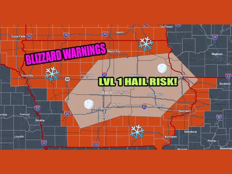
Iowa Blizzard Warning Unusual Setup Brings Sunday Morning Thunderstorms and Hail Risk Before Snowstorm Intensifies
IOWA — A rare and fast-changing weather setup is unfolding across the state as forecasters warn that thunderstorms and hail could strike Sunday morning before a powerful blizzard takes over later in the day. The unusual combination places parts of Iowa under both severe weather potential and blizzard warnings within the same storm system.
Meteorologists say the storm will begin with rain and scattered thunderstorms capable of producing small hail before temperatures quickly drop and the system transitions into heavy snow and dangerous wind conditions. The rapid change highlights how quickly weather patterns can shift across the Midwest during late winter storm events.
Rare Severe Weather Threat Inside a Blizzard Warning
Weather experts say the most unusual aspect of the system is the presence of thunderstorms embedded within a region already expected to see blizzard conditions.
Forecast models show a Level 1 marginal risk for hail-producing storms early Sunday morning across central and eastern Iowa. Areas including Des Moines, Marshalltown, Cedar Rapids, Iowa City, and Davenport could see thunderstorms capable of producing pocket-change sized hail.
While the hail threat itself is considered low-end, the presence of lightning and thunderstorms ahead of a major snowstorm is drawing attention from forecasters. This setup occurs when warm, unstable air briefly moves into the region ahead of a powerful cold front. Once the cold air surges in behind the storms, conditions are expected to deteriorate rapidly.
Changeover to Heavy Snow and Blizzard Conditions
Following the morning storms, temperatures across Iowa are forecast to fall quickly as the main winter storm arrives. Rain and thunderstorms will transition into snow during the late morning and afternoon hours.
Strong winds combined with falling snow could produce true blizzard conditions, especially across northern and western portions of the state where blizzard warnings have been issued.
Meteorologists warn that visibility could drop sharply as wind gusts increase and snow begins accumulating on roads. Travel conditions may deteriorate quickly once the changeover occurs. Cities including Sioux City, Fort Dodge, Mason City, and surrounding communities may see some of the strongest wind and snow impacts as the storm strengthens.
Fast-Changing Weather Creates Dangerous Travel Conditions
The biggest concern with this system is the speed at which conditions will shift. Drivers could experience rain or thunderstorms early in the day only to encounter heavy snow and blowing snow a few hours later.
Rapid temperature drops can also cause wet roads to freeze quickly, increasing the risk of icy surfaces. Combined with strong winds, visibility could fall to near zero in open areas.
Emergency officials often warn that storms with sudden transitions from rain to snow can be especially hazardous because road conditions can worsen before crews are able to respond. Residents across Iowa are encouraged to monitor forecasts closely and plan ahead if travel is necessary on Sunday.
A Dramatic Reminder of Midwest Weather Extremes
Storm systems like this are not common but are not unheard of during seasonal transitions in the central United States. The clash between lingering winter air and advancing spring warmth can produce dramatic weather swings within hours. The same atmospheric ingredients that produce thunderstorms can briefly appear ahead of powerful winter storms before colder air takes control.
For many residents, the event will serve as a vivid reminder of how unpredictable Midwest weather can be, especially in March when winter and spring often collide. Meteorologists say conditions should gradually stabilize once the snowstorm moves through, but strong winds and drifting snow could continue impacting travel even after the heaviest snowfall ends.
Residents across Iowa are encouraged to stay weather aware and prepare for rapidly changing conditions throughout the day. If you are experiencing changing weather conditions in your community, share your updates and photos with the newsroom at SaludaStandard-Sentinel.com to help others stay informed.