Indiana, Ohio, and Michigan Could See Another Clipper Late Week, With Freezing Drizzle Risk and Lake-Enhanced Snow Bands Thursday Night Into Friday
INDIANA, OHIO, AND MICHIGAN — A second clipper system is being watched for Thursday night into Friday morning, and while some areas may only see light snow, the bigger travel issue could be freezing drizzle across parts of Indiana, with higher, lake-enhanced snow totals possible downwind of the Great Lakes in portions of Ohio and Michigan.
Why This Clipper Matters After the First One
The outlook describes the Tuesday clipper as the “first of more to come,” with another fast-moving system lining up late week. Clippers often don’t produce blockbuster snow totals across the entire region, but they can create uneven impacts: a narrow corridor gets steadier snow, another area deals with a light glaze, and lake-driven bands can boost totals in favored spots.
That’s why even a “light” system can still create a messy commute, especially if temperatures sit near freezing during the overnight and early morning hours.
Freezing Drizzle Could Be the Main Hazard in Indiana
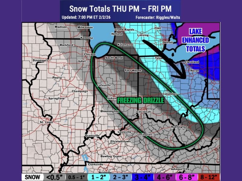
The forecast map places a long, diagonal zone labeled “freezing drizzle” across much of Indiana, stretching from near the Chicago/northwest Indiana area through central Indiana and toward the Ohio River valley. Freezing drizzle is a high-impact hazard because it can create slick roads quickly without heavy precipitation showing up on radar.
This is the kind of setup where totals may look small on paper, yet untreated roads, ramps, and bridges can turn hazardous, especially late Thursday night into Friday morning when surface temperatures are coldest.
Ohio and Michigan Could See Higher Totals in Lake-Enhanced Areas
While Indiana trends toward the ice-type concern, the snow map shows higher snowfall potential across parts of Ohio and Michigan, particularly where lake enhancement can kick in. The graphic highlights a zone of lake-enhanced totals aimed into Northeast Ohio, with the higher end of the color shading clustering closer to the Great Lakes shoreline and snowbelt areas.
In Michigan, the map also shades parts of the Lower Peninsula for accumulating snow, suggesting that even if the clipper’s main moisture is limited, lake processes could add inches in localized corridors.
What the Snow Totals Map Suggests for Thursday PM to Friday PM
The mapped snowfall window runs Thursday evening through Friday evening, and the overall theme is that many places may land on the lighter end of totals, while the higher numbers appear concentrated in a narrower band. Portions of Ohio and Michigan are depicted with potential for a couple inches in favored areas, while parts of Indiana look less like a snow story and more like a precipitation-type problem.
That split matters: drivers in one county might deal with slushy roads, while the next county over is battling thin ice.
What To Watch Over the Next Updates
Small track changes will determine where the snow band sets up and where freezing drizzle becomes most likely. If colder air arrives faster, the drizzle zone can shrink and snow coverage can expand. If moisture is shallow and temperatures hover near freezing, freezing drizzle becomes more dominant, especially in Indiana and areas just south of the steadier snow band.
If you’re in Indiana, Ohio, or Michigan, have you already dealt with slick roads from the first system this week? Share what conditions look like where you are and keep following updates at SaludaStandard-Sentinel.com.