Indiana Faces Strong Storm Line with 50+ MPH Wind Gusts, Flash Freeze Threat Overnight
INDIANA — A fast-moving line of storms is surging across Indiana this evening, bringing strong wind gusts up to 50+ mph, heavy rainfall, and a sudden drop in temperatures that could trigger flash-freeze conditions overnight.
Meteorologists warn that this storm system is moving quickly from southwest to northeast, cutting a path through Evansville, Bloomington, Indianapolis, and Fort Wayne, and leaving behind rapidly changing road and weather conditions.
Strong Winds and Sudden Temperature Drop
Radar images show an intense squall line sweeping through central Indiana with winds of 40 to 55 mph, capable of causing isolated damage, especially to unsecured outdoor items.
Residents are advised to secure decorations and loose objects — particularly holiday inflatables — and to park vehicles safely away from trees or power lines.
Once the line passes, temperatures are expected to plummet sharply, with bitter cold air surging in behind it. This shift could turn wet pavement into slick, icy surfaces within hours, making for dangerous evening and early-morning travel conditions.
“These wet roads can turn into skating rinks in a hurry,” forecasters said. “Drivers should be cautious as flash freezing is likely once the storm moves out and temperatures drop below freezing.”
Rain Changing to Wintry Mix Up North
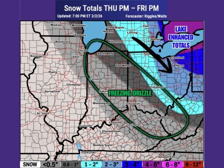
For northern counties including Lafayette, Muncie, and Fort Wayne, rain may transition to a wintry mix or light snow as the cold air deepens overnight. Though major snow accumulation isn’t expected, the combination of freezing rain and icy surfaces could create hazardous travel for the Friday morning commute.
Southern and central parts of the state will see the most intense winds, while northern Indiana faces the greatest potential for ice or snow flurries late tonight.
Flash Freeze and Travel Advisory
Forecasters warn that temperatures could fall rapidly after 9 p.m., leading to widespread flash freezing of any residual moisture on roads and sidewalks.
Key Concerns Tonight:
- Wind gusts between 40–55 mph
- Falling temperatures behind the front — possibly below freezing within hours
- Risk of icy spots developing by early Friday
- Visibility issues from heavy rain and brief wind bursts
Drivers are urged to slow down, allow extra travel time, and avoid sudden braking on slick roads.
Cold Air Settles In Behind the Storms
By early Friday morning, most of the rain will have cleared out, but temperatures will remain well below freezing statewide. Central Indiana is expected to wake up to wind chills in the teens, marking a stark shift from today’s milder air.
Up north, scattered flurries or freezing drizzle could linger through the morning commute.
Meteorologists say this event will serve as a sharp reminder of how quickly Indiana weather can turn dangerous — from heavy rain to icy roads in just a few hours.
“Don’t let this one catch you off guard,” forecasters warned. “Stay alert, stay safe, and prepare for changing conditions overnight.”
Stay tuned for ongoing updates and statewide weather alerts at SaludaStandard-Sentinel.com.