Indiana Emergency: Lake Village Reportedly Hit by Powerful Tornado as Radar Indicates Possible EF-4 Intensity
INDIANA — A potentially devastating tornado may have struck the community of Lake Village, Indiana, with radar data suggesting an extremely dangerous storm capable of EF-4 level intensity, according to early severe weather analysis and warnings circulating among meteorologists.
The storm system moved rapidly across parts of northwest Indiana, producing intense radar signatures that strongly indicate a large and violent tornado embedded within a powerful supercell thunderstorm.
Officials and forecasters urged residents in the storm’s path to remain in shelter immediately as the life-threatening situation unfolded.
Radar Signatures Indicate Violent Tornado
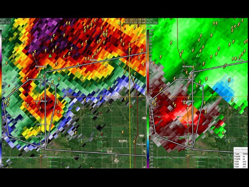
Dual-polarization radar imagery captured during the storm shows strong evidence of a tight and intense rotation near Lake Village, along with a pronounced debris signature that can appear when a tornado is lifting objects into the air.
Meteorologists monitoring the storm described it as exceptionally dangerous, noting radar indicators that can sometimes be associated with violent tornadoes capable of producing catastrophic damage.
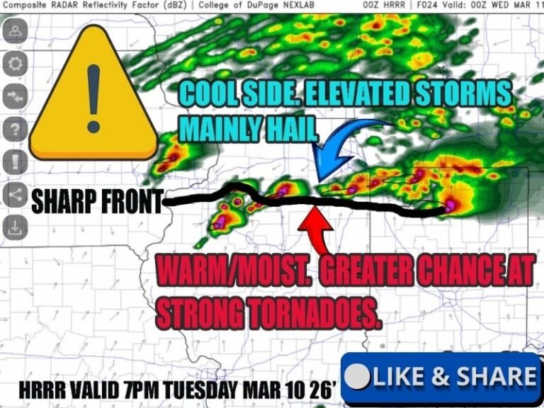
The Storm Prediction Center had previously warned of the possibility of strong tornadoes across parts of the Midwest, and this storm appeared to meet many of the atmospheric conditions associated with those warnings.
Tornado Path Near Lake Village and Surrounding Communities
The rotating storm tracked across portions of northwest Indiana, including areas near:
- Lake Village
- Schneider
- Roselawn
- Fair Oaks
The radar presentation showed an extremely strong storm core accompanied by intense lightning activity and powerful rotational winds, raising concerns that communities directly in the storm’s path could experience significant damage.
Emergency officials urged residents to remain in interior rooms on the lowest floor of buildings and away from windows until the storm threat fully passed.
Exceptionally Dangerous Severe Weather Event
Forecasters noted that the storm developed during a broader severe weather outbreak across the Midwest and Southern Plains.
The atmospheric setup included:
- High instability in the lower atmosphere
- Strong wind shear supporting rotating supercells
- Favorable conditions for large hail and tornado development
Such ingredients can allow storms to rapidly intensify and produce long-lived tornadoes, sometimes with very little warning.
Damage Reports Still Emerging
At this stage, it remains too early to determine the full extent of damage caused by the storm near Lake Village.
Emergency crews and storm survey teams will likely assess the area in the coming hours and days to determine:
- Whether a tornado touched down
- The length of the storm’s damage path
- The official strength rating of the tornado
The National Weather Service typically conducts post-storm damage surveys before assigning an official EF rating.
Residents Urged to Stay Alert
Because storms remained active across the region at the time of the radar scans, meteorologists stressed the importance of staying weather aware.
Residents across the Midwest were urged to monitor warnings closely and remain in shelter until officials confirm that the threat has passed.
Stay with SaludaStandard-Sentinel.com for continuing updates as more information becomes available about the powerful storm that impacted Lake Village, Indiana.