Increasing Model Support Suggests Higher Snow Potential Sunday Morning as Trends Favor Greater Impact Across Western Carolinas
NORTH CAROLINA — Forecast confidence is increasing as weather models continue strengthening support for a Sunday morning snowfall event, with new signals pointing toward higher totals and greater impacts across the western Carolinas. After nearly ten days of monitoring this developing pattern, meteorologists say the latest trends are finally beginning to take shape.
Models Shift Toward a More Likely Snow Scenario
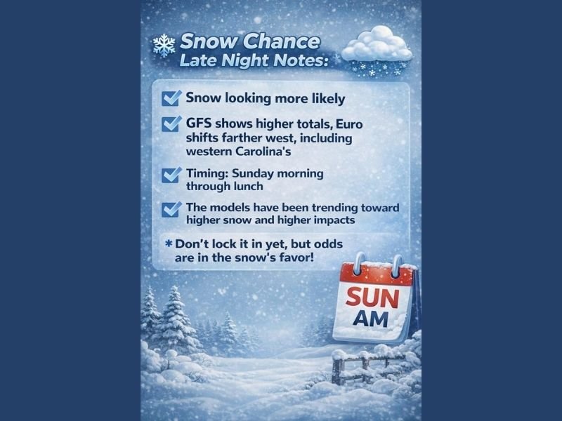
The latest discussion notes that snow is looking more likely, with multiple model runs showing improving alignment. Both the American (GFS) and European (Euro) models indicate accumulating snow, although with important differences:
- The GFS is showing higher totals, increasing the risk for stronger impacts.
- The Euro shifts the snow farther west, including parts of the western Carolinas in its projected snowfall zone.
While confidence is rising, forecasters stress that some uncertainty remains. The message is clear: “Don’t lock it in yet, but odds are in the snow’s favor.”
Timing Expected From Sunday Morning Through Lunch
Newly refined model timing places the potential snowfall window from Sunday morning through lunchtime. This consistent timing across multiple runs adds weight to the increasing confidence, though the final track and intensity will determine how widespread and impactful the system becomes.
For now, signals continue trending toward higher snow and higher impact potential, especially compared to earlier outlooks.
Why Confidence Is Increasing After Days of Uncertainty
For nearly ten days, forecasters have been highlighting this pattern while also warning that models could shift dramatically. The latest updates acknowledge that forecasting uncertainty can feel frustrating for the public, but transparency remains a priority.
The forecaster notes:
- The goal is early identification of potential hazards.
- Updates are provided as soon as confidence increases.
- Model inconsistency earlier in the week has now transitioned into clearer, more aligned trends.
This shift is why the upcoming forecast period — particularly tomorrow — is expected to provide “a big day for clarity.”
Snow Odds Improve, but Final Details Still Developing
Although confidence is rising, meteorologists continue to caution that details such as exact placement, intensity and totals may still adjust as newer data arrives. The western Carolinas appear most favored at this stage, but all residents in the region are encouraged to follow updates closely as the system approaches.
The Saluda Standard-Sentinel will continue monitoring every model run and provide updated coverage as confidence sharpens. Readers can share whether they are preparing for possible Sunday morning snow at SaludaStandard-Sentinel.com.