Illinois, Wisconsin, and Iowa Face Overnight Heavy Rain Surge as Stateline Areas See 0.5 to 1.3 Inches With Persistent Showers Into Friday Morning
ILLINOIS, WISCONSIN, IOWA — A widespread rain system is moving across the Stateline region tonight, bringing steady rainfall that is expected to continue through the overnight hours into early Friday morning. Forecasters indicate that most areas will receive between half an inch to over an inch of rain, with some localized spots seeing even higher totals.
The system has already begun spreading across key cities, creating a very wet night ahead for residents across the region.
Rain Overspreads Region With Steady Overnight Showers
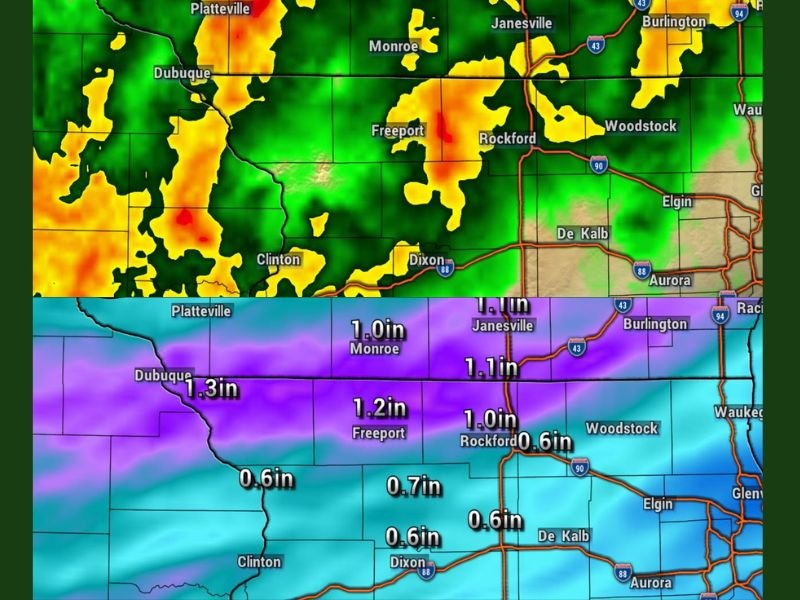
Radar imagery shows a broad area of rain covering much of northern Illinois, southern Wisconsin, and eastern Iowa. Cities including Rockford, Freeport, Monroe, and Janesville are already experiencing moderate to heavy rainfall.
The rain is expected to remain persistent throughout the night, with no significant breaks anticipated. This steady pattern increases the likelihood of accumulation across a wide area rather than isolated pockets. Drivers and overnight commuters are being urged to remain cautious as road conditions may deteriorate.
Rainfall Totals Expected to Reach Over an Inch in Some Areas
Forecast models indicate that rainfall totals will vary across the region but remain significant overall. Areas near Dubuque could see up to 1.3 inches of rain, making it one of the highest totals in the region.
Freeport is expected to receive around 1.2 inches, while Monroe, Rockford, and Janesville could see close to or slightly above 1 inch. Other areas, including parts of northern Illinois, are forecast to receive between 0.6 and 0.7 inches. These totals are expected to accumulate by early Friday morning, potentially leading to ponding on roads and minor localized flooding.
Thunder Possible but Severe Weather Not Expected
While embedded thunderstorms may develop at times, forecasters are not currently expecting severe weather overnight. The system appears to be more focused on steady rainfall rather than intense storm activity.
However, occasional lightning and brief heavier downpours cannot be ruled out as the system continues moving through. Officials say they will continue monitoring radar trends in case conditions change.
Wet Conditions Continue Into Early Friday Morning
The rain is expected to persist into the early morning hours before gradually tapering off. By sunrise, much of the region will have already received the bulk of the rainfall.
The lingering moisture could lead to slick roads during the morning commute, especially in areas that receive heavier overnight totals. Residents are advised to allow extra travel time and remain aware of changing conditions.
System Highlights Active Spring Weather Pattern
This event is another example of the active spring weather pattern currently impacting the Midwest. Frequent systems are bringing waves of precipitation across multiple states.
While this round is not expected to bring severe weather, the consistent rainfall still poses challenges for travel and localized drainage.
More updates are expected as the system moves out and conditions evolve. If you’re experiencing heavy rain in your area or notice flooding concerns, share your updates with us at SaludaStandard-Sentinel.com.