Illinois Tornado Outbreak Update: NWS Confirms Three Tornadoes in Central Illinois Including EF-1 Storms Near Havana, Topeka, and Green Valley
ILLINOIS — The National Weather Service has confirmed that three tornadoes touched down across central Illinois Tuesday night, adding new details to a severe weather outbreak that moved across parts of the Midwest earlier this week. Preliminary storm surveys show that the tornadoes ranged from EF-0 to EF-1 intensity, producing winds between 80 and 100 mph and carving paths across multiple counties.
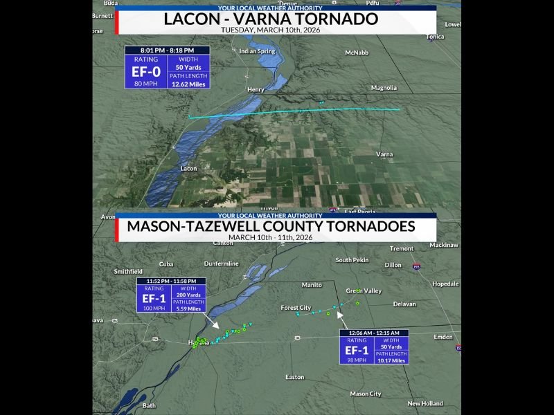
The confirmed tornadoes include the Lacon–Varna tornado, the Havana–Topeka tornado, and the Forest City–Green Valley tornado, each producing varying levels of damage as the storms moved through the region late Tuesday into early Wednesday.
EF-0 Tornado Tracked From Lacon to Varna
The first confirmed tornado occurred near Lacon and Varna in Marshall County, where survey teams determined the storm reached EF-0 strength with maximum winds around 80 mph.
According to the National Weather Service survey, the tornado was on the ground from 8:01 p.m. to 8:18 p.m. and traveled approximately 12.62 miles across the area. Officials said the tornado reached a width of about 50 yards, producing localized damage along its path as it moved eastward across rural sections of central Illinois.
EF-1 Tornado Struck Near Havana and Topeka
A stronger tornado later developed in Mason County, tracking between Havana and Topeka late Tuesday night. Survey data shows the tornado reached EF-1 intensity with winds up to 100 mph, making it the strongest of the three confirmed storms.
The tornado was on the ground from 11:52 p.m. to 11:58 p.m., traveling approximately 5.59 miles with a width of around 200 yards. Meteorologists say storms capable of producing winds of this strength can cause damage to structures, trees, and power lines along the tornado’s path.
Another EF-1 Tornado Confirmed Near Forest City and Green Valley
A third tornado developed shortly after midnight in Tazewell County, traveling between Forest City and Green Valley. Officials determined the tornado reached EF-1 strength with maximum winds estimated near 98 mph.
The storm remained on the ground from 12:06 a.m. to 12:15 a.m., producing a path roughly 10.17 miles long with a width near 50 yards. While damage reports are still being evaluated, survey teams say the storm likely caused scattered structural and tree damage along parts of its path.
Storm System Produced Multiple Tornadoes Across Region
The tornadoes occurred as a powerful storm system moved through the Midwest Tuesday night, producing conditions favorable for rotating thunderstorms capable of spawning tornadoes.
Meteorologists say strong wind shear and atmospheric instability helped several storms intensify quickly across parts of Illinois, leading to the confirmed tornado touchdowns. Storm survey teams continue analyzing radar data and damage reports to determine whether additional tornadoes may have occurred elsewhere in the region.
Officials Continue Assessing Damage
Local emergency management agencies and weather officials are continuing to assess damage in affected communities. While the tornadoes were relatively short-lived, winds near 100 mph can still produce significant localized damage.
Residents across central Illinois are encouraged to report storm damage to local authorities to help meteorologists complete their surveys. Stay with Saluda Standard-Sentinel for continuing updates as weather officials finalize storm reports and release additional information about this week’s severe weather across Illinois and the Midwest.