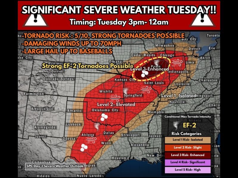
Illinois, Missouri, Iowa and Oklahoma Brace for Major Tuesday Severe Weather Threat With Strong EF-2 Tornadoes, 70 MPH Winds and Giant Hail Possible
UNITED STATES — Meteorologists are closely monitoring a potentially significant severe weather outbreak developing Tuesday afternoon into the overnight hours, with storms expected to stretch from the Southern Plains into the Midwest.
Forecast models suggest a volatile atmospheric setup that could produce supercell thunderstorms capable of generating strong tornadoes, destructive winds, and very large hail across multiple states.
The most intense weather could develop between roughly 3 p.m. Tuesday and midnight, when conditions may become favorable for explosive storm development.
Enhanced Severe Weather Risk Across the Midwest
Forecasters highlight a Level 3 “Enhanced Risk” zone across portions of eastern Iowa, Missouri, and into Illinois, where the ingredients for severe storms could come together most strongly.
Meteorologists say the region may sit near a warm front and a developing surface low pressure system, which could act as a focal point for rapidly intensifying storms.
Atmospheric energy levels — known as CAPE (Convective Available Potential Energy) — are expected to be unusually high for this time of year. Combined with wind shear along the boundary, these conditions could allow discrete supercell thunderstorms to form.
If storms remain isolated rather than clustering together, forecasters warn that the tornado risk could increase significantly, including the potential for strong EF-2 tornadoes.
Large hail — potentially as large as baseballs — is also possible with the most intense supercells.
Southern Plains Also Facing Severe Storm Threat
Further south, the Southern Plains including Oklahoma and parts of Texas and Missouri could also experience severe storms Tuesday.
While the overall tornado threat may be slightly lower compared to the Midwest, forecasters say storms could still produce damaging wind gusts approaching 70 mph and large hail.
Clusters of storms may develop across the region during the afternoon and evening hours, with a few isolated tornadoes also possible.
The exact storm mode remains uncertain, but meteorologists say both supercells and storm clusters may develop across the Plains.
Storms Could Continue Into Overnight Hours
One of the key concerns with this event is that the severe weather threat may continue well into the nighttime hours.
Nighttime tornado events can be particularly dangerous because reduced visibility makes storms harder to detect and people are often asleep when warnings are issued.
Forecasters are urging residents across the threatened areas to have a severe weather plan in place before storms begin developing.
Residents Urged to Prepare Ahead of Time
With the potential for strong storms spanning multiple states, emergency officials recommend preparing ahead of Tuesday’s weather event.
Key safety preparations include:
- Keeping a weather alert system active overnight
- Identifying a safe shelter location inside your home
- Having closed-toe shoes and emergency supplies nearby
- Staying informed through local weather alerts
While forecast details will continue to evolve, meteorologists emphasize that the atmospheric setup has the potential to produce dangerous storms capable of significant impacts across parts of the Plains and Midwest.
Residents are encouraged to closely monitor forecast updates as Tuesday approaches. Stay with SaludaStandard-Sentinel.com for the latest severe weather updates as meteorologists track this developing storm system across the United States.