Illinois, Missouri and Texas Brace for Major Tuesday Severe Weather Threat as Strong Tornadoes and Baseball-Size Hail Become Possible
UNITED STATES — Meteorologists are closely monitoring a large and potentially dangerous severe weather outbreak expected Tuesday afternoon through the overnight hours, with storms capable of producing strong tornadoes, damaging winds, and extremely large hail across parts of the Midwest and Southern Plains.
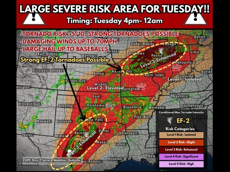
Forecast guidance indicates the threat may develop in two separate regions simultaneously, stretching from Texas and Oklahoma into Missouri, Illinois, and Indiana as atmospheric conditions become favorable for powerful thunderstorms.
The Storm Prediction Center has placed portions of these regions under a Level 3 “Enhanced Risk” for severe weather, signaling an increased likelihood of intense storms.
Midwest Could See Strong Tornado Potential
One of the most concerning areas in the forecast stretches across eastern Iowa, northern Missouri, and central Illinois, where atmospheric ingredients could combine to produce discrete supercell thunderstorms capable of strong tornadoes.
Forecasters say a warm front interacting with a surface low pressure system may create a triple-point setup — a feature often associated with significant tornado events.
The environment may also feature very high atmospheric instability, with CAPE values exceeding 3000 in some areas, providing explosive fuel for developing storms.
If storms form in this environment, meteorologists warn that strong tornadoes, including those reaching EF-2 strength or higher, cannot be ruled out.
Cities near the enhanced risk corridor include:
- Peoria, Illinois
- Chicago metro region
- Cedar Rapids, Iowa
- St. Louis, Missouri
- Indianapolis, Indiana
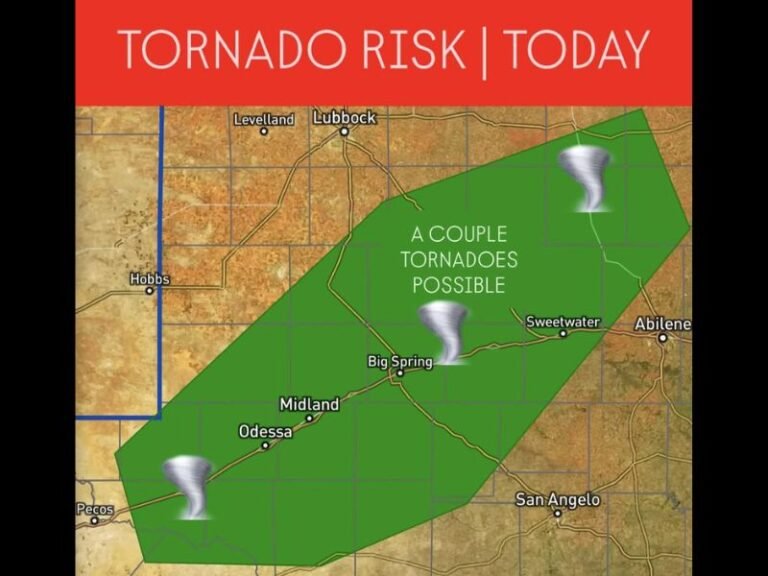
Southern Plains Facing Severe Storm Clusters
Farther south, another severe weather zone is expected across Texas, Oklahoma, and parts of Kansas, where storms may develop in clusters or organized lines.
In this region, the primary threats may include:
- Damaging wind gusts approaching 70 mph
- Large hail potentially reaching baseball size
- Isolated tornadoes within stronger supercells
Communities across Wichita Falls, Dallas, Abilene, and Oklahoma City could experience strong storms as the system moves eastward through the evening.
Severe Storm Window Extends Into the Night
Meteorologists say the main severe weather window is expected between approximately 4 p.m. and midnight, although storms may continue later into the night in some areas.
Nighttime severe weather events can be especially dangerous because many people are asleep when warnings are issued, reducing the amount of time they have to react.
Forecasters recommend residents across the risk areas ensure they have multiple ways to receive weather alerts, including wireless emergency alerts and NOAA weather radios.
All Severe Weather Hazards on the Table
Because of the powerful atmospheric setup, meteorologists say all major severe weather hazards are possible Tuesday, including:
- Strong tornadoes
- Damaging winds
- Large hail
- Frequent lightning
- Heavy rainfall in stronger storms
The evolving storm environment means conditions will need to be monitored closely as new forecast data arrives.
Residents across the Midwest and Southern Plains are encouraged to review safety plans and remain weather aware throughout Tuesday and Tuesday night.
Stay with SaludaStandard-Sentinel.com for continuing updates as meteorologists track this developing severe weather outbreak across the central United States.