Illinois, Indiana and Western Ohio Under Level 3 Severe Risk With Supercells, 2 Inch Hail and Damaging Wind Line Expected Thursday
ILLINOIS — A heightened severe weather risk has been issued for Thursday, with parts of Illinois, Indiana, and western Ohio now under a Level 3 threat as conditions align for dangerous storms capable of producing large hail and damaging winds.
The latest outlook indicates storms will develop during the late afternoon before intensifying and organizing into a more widespread line by evening.
Supercells Expected to Develop Late Afternoon
Initial storm development is expected to begin in the late afternoon hours, particularly across Illinois and Indiana. These early storms are likely to take the form of discrete supercells, which are known for producing the most intense severe weather.
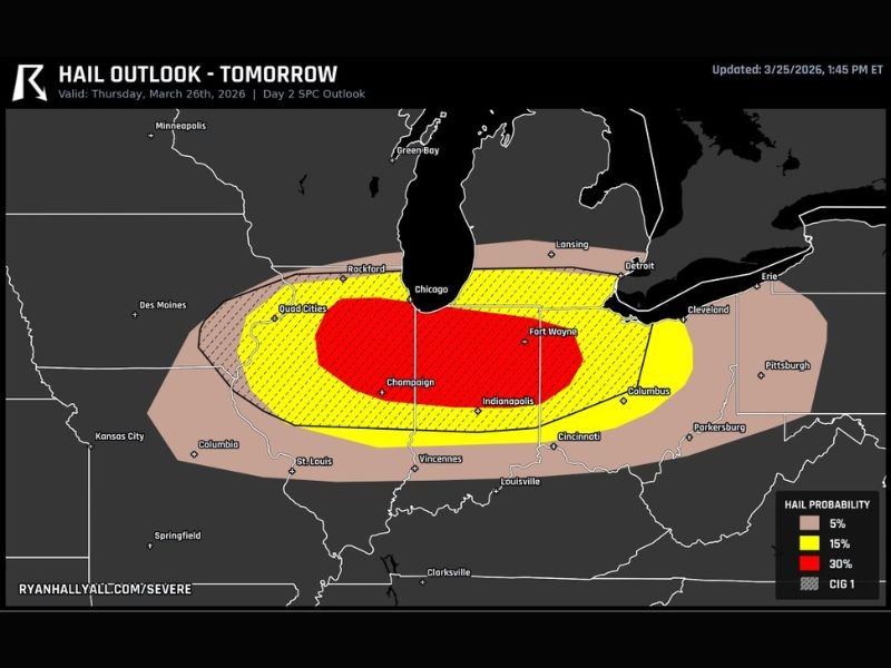
The primary concern during this phase will be large hail, with projections indicating the potential for hailstones exceeding 2 inches in diameter. These sizes can cause significant damage to vehicles, roofs, and crops.
Cities including Champaign, Indianapolis, and areas near the Quad Cities fall within this higher-risk zone for early storm development.
Large Hail Threat Peaks Before Transition to Wind Event
As storms mature, the threat of large hail will be at its highest during the initial supercell phase. The atmospheric setup supports strong updrafts, which are critical for producing large hail cores.
However, as the evening approaches, these individual storms are expected to merge into a more organized line. This transition will shift the primary threat from hail to damaging straight-line winds.
This type of evolution is common in strong spring storm systems and can expand the area of impact significantly.
Damaging Wind Line Expected to Sweep Into Western Ohio
By evening, storms are forecast to consolidate into a fast-moving line that will push eastward into western Ohio. Areas including Fort Wayne, Columbus, and surrounding regions could see the strongest wind impacts during this phase.
Wind gusts within this line may become strong enough to down trees, damage structures, and cause power outages. The transition to a linear system increases the risk of widespread wind damage across multiple states.
Travel conditions may deteriorate quickly as this line moves through during peak evening hours.
Warm Sector Conditions Increase Overall Storm Intensity
The environment ahead of these storms is expected to be warm and unstable, often referred to as the “warm sector.” This region provides the fuel necessary for storms to grow stronger and more organized.
Residents within this zone should remain especially alert, as conditions can change rapidly once storms begin to develop.
The combination of instability and wind shear is what is driving the elevated Level 3 risk across the region.
Residents Urged to Stay Alert Ahead of Thursday Storms
With multiple hazards expected—including large hail and damaging winds—residents across Illinois, Indiana, and western Ohio are encouraged to monitor forecasts and prepare for potential severe weather.
The timing of these storms during late afternoon and evening hours adds to the risk, particularly for commuters and those with outdoor plans.
If you are in these impacted states, share what conditions are like in your area and stay connected with others by visiting SaludaStandard-Sentinel.com.