Illinois Faces Overnight Storm Line From Iowa With Lightning and Wind Risk but Widespread Severe Threat Remains Low
ILLINOIS — A line of storms developing over Iowa is expected to move into western Illinois late tonight, bringing lightning and the potential for gusty winds, though widespread severe weather is not currently anticipated.
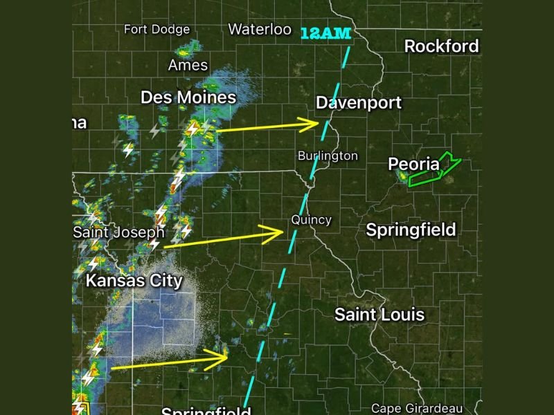
Current radar trends show storms clustered near areas like Des Moines and Kansas City, gradually pushing east toward the Mississippi River. Cities such as Davenport, Burlington, and Quincy sit along the projected path, with the system expected to reach parts of Illinois around midnight.
Storm Line Tracking Toward Western Illinois Overnight
The storm activity remains relatively unorganized as it moves eastward, which is a key reason why the severe threat is considered limited at this time. While lightning and moderate rainfall are likely, the structure of the storms does not currently support widespread severe outbreaks.
The leading edge of the system is expected to cross into western Illinois near the Mississippi River, impacting areas from the Quad Cities region down toward western-central Illinois overnight.
Damaging Wind Risk Still Possible in Isolated Areas
Although the overall severe threat is low, forecasters note that pockets of stronger wind gusts cannot be ruled out. As storms organize slightly while crossing into Illinois, isolated areas could briefly experience stronger wind bursts.
Communities across western and central Illinois, including areas near Peoria and Springfield, may see passing storms through the overnight hours. However, these are expected to weaken as they continue eastward.
No Widespread Severe Weather Expected Tonight
The most important takeaway from current conditions is that the environment does not appear favorable for a significant severe weather outbreak. Storm intensity remains limited, and large-scale severe impacts are not expected across Illinois tonight.
Residents can expect periods of rain, lightning, and occasional thunder, but the situation does not currently indicate a high-risk event. Still, weather conditions can evolve, and changes in storm strength remain possible overnight.
Stay Alert Despite Lower Risk
Even with a lower severe threat, overnight storms can still create localized hazards, particularly for those traveling or without access to weather alerts. Officials recommend keeping a reliable way to receive warnings, especially while sleeping.
This system serves as a reminder that even weaker storm setups can still bring brief impacts, particularly with wind and lightning.
If you notice changing weather conditions overnight in your area, share your updates with us at SaludaStandard-Sentinel.com and help keep your community informed.