Illinois Faces a Very Busy Week of Severe Weather From Sunday Through Saturday With Tuesday and Wednesday Posing the Most Significant Threat Statewide
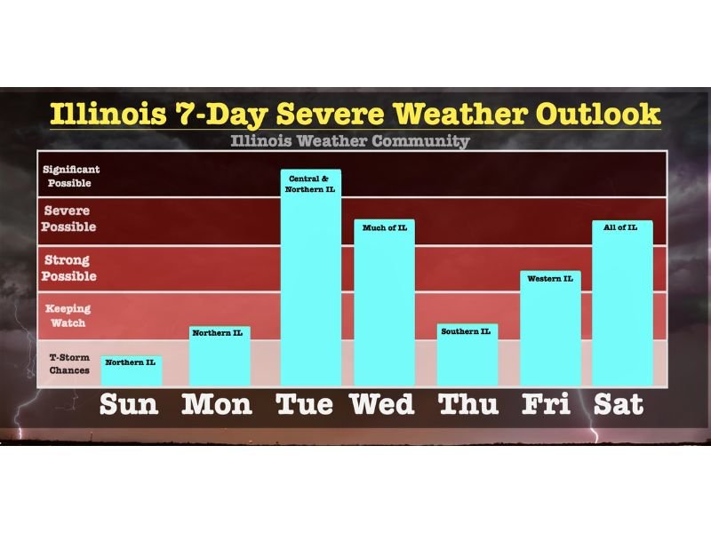
ILLINOIS — A very active and potentially dangerous week of severe weather is taking shape across Illinois, with storm threats forecast on multiple days from Sunday through Saturday. According to the Illinois Weather Community 7-Day Severe Weather Outlook, Tuesday carries the highest risk of the week with significant severe weather possible across central and northern Illinois, while Wednesday and Saturday also pose serious threats for much of the state.
Sunday and Monday Bring Lower but Watchable Threats
Sunday brings a limited storm chance across northern Illinois north of Interstate 74 between 2 PM and 7 PM. These storms may produce heavy downpours and small hail but the overall severe risk remains low and is not a major concern for most residents.
Monday is expected to be largely dry as a strong atmospheric cap prevents storm development during the day. However, storms drifting south from the upper Midwest into northern Illinois near midnight Monday night are possible, with strong winds the main concern. Confidence in this scenario remains low overall.
Tuesday Is the Most Dangerous Day of the Week
Tuesday represents the highest severe weather risk of the entire week for Illinois. A strongly sheared, very unstable, warm and moist environment will be in place, meaning any storms that develop will intensify rapidly and become severe. The primary timing window for the greatest threat runs from 4 PM to 11 PM.
The highest severe risk is focused west of the Illinois River with potential extending as far east as Interstate 57 and south to Interstate 72. Eastern Iowa and northeast Missouri are expected to be the initiation zone, with storms racing northeast into central and northwestern Illinois during the evening hours. All storm modes including tornadoes, large hail, and damaging winds are possible.
Wednesday Brings Widespread Wind Threat Across Illinois
Wednesday’s cold front swinging through the state could ignite storms that race southeast and impact much of Illinois between 3 PM and 11 PM. Damaging winds are expected to be the primary hazard on Wednesday, making it another day to watch closely for widespread severe weather potential across the state.
Thursday Through Saturday Round Out an Active Week
Thursday carries a low severe threat though southern Illinois could be clipped by stronger storms depending on cold front placement. Friday brings storm potential mainly across Iowa, Missouri, and the Plains, with western Illinois worth monitoring Friday night. Saturday closes the week with all of Illinois facing severe possible conditions as another cold front moves through during peak afternoon severe weather hours.
Are you preparing for this active week of weather? Stay informed at SaludaStandard-Sentinel.com.