Illinois and Missouri Face 25 to 40 MPH Wind Gusts From Chicago and Rockford to St Louis and Springfield as Warm Temperatures Surge Wednesday
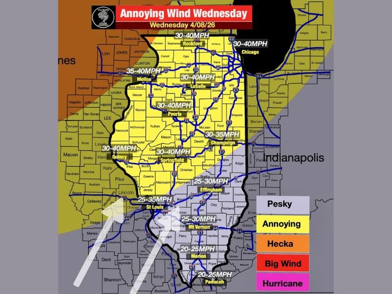
ILLINOIS AND MISSOURI — Strong and persistent winds are expected to sweep across Illinois and parts of Missouri on Wednesday, with gusts ranging from 25 to 40 miles per hour creating challenging outdoor conditions across major cities including Chicago, Rockford, Peoria, Springfield, and St. Louis.
While the winds may bring a boost in temperatures, they are also expected to create widespread disruptions throughout the day.
Gusty South Winds Spread Across Illinois and Missouri
Forecast data shows widespread south winds increasing throughout the region, with many areas expected to see gusts between 30 and 40 MPH.
Northern Illinois, including Chicago and Rockford, will likely experience some of the strongest gusts, while central areas such as Peoria, Bloomington, and Springfield will also see consistent winds in the 30 to 40 MPH range.
Southern portions of the region, including areas near Effingham and Mount Vernon, may see slightly lower but still noticeable gusts between 25 and 30 MPH.
Wind Impacts Expected Across Major Cities
The strength of these winds will be felt across urban and rural areas alike, with cities such as Chicago, Peoria, Springfield, and St. Louis all falling within the higher impact zone.
Drivers on highways and open roads may encounter difficulty maintaining control, especially in high-profile vehicles. Sudden gusts can also impact travel on bridges and elevated roadways. Loose outdoor items, including patio furniture and decorations, may be blown around, creating minor hazards in neighborhoods.
Warmer Temperatures Arrive With Wind Surge
One of the key impacts of these strong southerly winds is the arrival of warmer air across the region. Temperatures are expected to climb into the 70s for many areas, marking a shift toward more springlike conditions.
This warming trend will be noticeable after recent cooler days, though the strong winds may make conditions feel less comfortable despite the higher temperatures. The combination of warmth and wind is typical of spring transition patterns across the Midwest.
Conditions May Feel Uncomfortable Throughout the Day
Despite the pleasant temperatures, the persistent winds will likely make outdoor conditions feel less stable and more uncomfortable.
Walking outdoors, commuting, or spending time outside may be impacted by continuous gusts, with wind speeds strong enough to affect balance and visibility in some cases. Dry conditions combined with gusty winds may also increase the spread of dust and debris in certain areas.
No Severe Weather but Nuisance Impacts Likely
While these winds are not expected to reach severe levels, they will still create nuisance-level impacts across the region.
There is no indication of widespread severe weather tied directly to this system, but the strength and consistency of the winds will make them hard to ignore throughout the day. Residents should remain aware of changing conditions and take basic precautions when heading outdoors.
Windy Pattern Marks Ongoing Spring Transition
This wind event is part of a broader springtime transition pattern, where stronger pressure gradients and shifting air masses lead to gusty conditions across the Midwest. As the season progresses, similar setups may continue to bring windy and variable weather to the region.
Residents are encouraged to stay updated on forecasts and prepare for additional spring weather changes in the coming days. Are you noticing strong winds in your area Wednesday? Share your experience with us at SaludaStandard-Sentinel.com.