Illinois and Indiana Storm Whiplash: Thunderstorms Could Turn to Snow Overnight as Powerful Cold Front Crashes In
ILLINOIS — A rapidly intensifying storm system moving across the Midwest could deliver dramatic weather changes across Illinois and Indiana late Sunday into early Monday, with forecasters warning that thunderstorms may quickly transition into snowfall within just a few hours.
Meteorological models show a powerful cold front sweeping across the region overnight, producing heavy rain and thunderstorms before sharply colder air arrives behind the system. As temperatures plunge, precipitation could change from rain to snow across parts of the Midwest by early Monday morning.
Storm Line Expected to Sweep Through Late Sunday Night
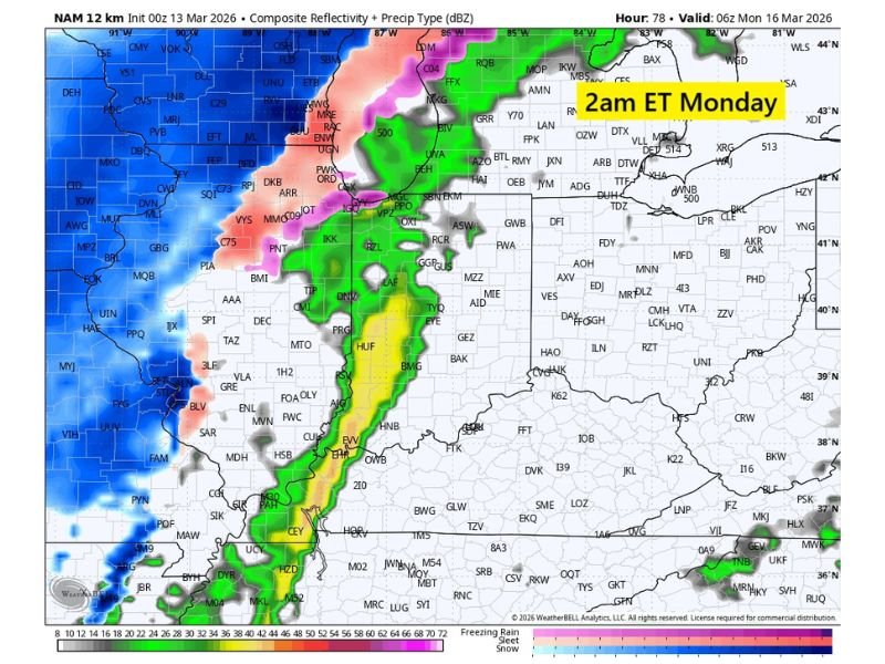
Forecast models indicate a strong line of thunderstorms developing ahead of the advancing cold front Sunday evening. This storm line is expected to move northeast across the Mississippi Valley and into Illinois and Indiana during the overnight hours.
Radar projections show intense bands of rain and thunderstorms stretching from the lower Mississippi Valley northward into the Midwest. As the system progresses eastward, cities across western Illinois, central Illinois, and parts of Indiana may see periods of heavy rainfall, lightning, and gusty winds overnight. The storm line is expected to remain fairly organized as it tracks across the region, with some areas experiencing intense bursts of rain as the cold front approaches.
Rapid Temperature Drop Could Trigger Rain-to-Snow Changeover
Behind the storm line, much colder air is expected to surge southward into the Midwest. Forecasters say the cold air could arrive quickly enough to change precipitation from rain to snow across northern sections of Illinois and nearby areas.
Forecast data shows the possibility of snow developing as the cold front passes, particularly during the early hours of Monday morning. The transition could occur quickly as colder air wraps into the storm system from the northwest. In some areas, residents may witness rain or thunderstorms during the late evening followed by snowfall before sunrise Monday.
Dramatic Dew Point Drop Highlights Strength of the Front
One of the most striking signals of the storm’s intensity is the projected drop in atmospheric moisture. Forecast models suggest dew points across the region could plunge by roughly 30 degrees within just six hours as the front moves through.
Such a rapid change is a classic indicator of a powerful cold front and signals the arrival of much drier and colder air behind the storm system. This sharp shift in air mass could accelerate the rain-to-snow transition while also bringing gusty winds and falling temperatures across the region.
Monday Morning Could Look Very Different Across the Midwest
By early Monday morning, areas that experienced thunderstorms overnight may wake up to much colder conditions. Snow showers may continue in some northern areas as the storm system pulls away.
Travel conditions could become slick in locations where rain quickly changes to snow and temperatures fall below freezing. Bridges and elevated roads are particularly vulnerable to rapid icing during these types of transitions. Meteorologists note that forecast details may still change as the storm approaches, especially regarding how far south snowfall may extend.
Forecast Still Evolving Ahead of Weekend Storm
Because the system is still several days away, meteorologists emphasize that the exact placement of rain, thunderstorms, and snowfall may shift as newer forecast data becomes available. However, confidence continues to increase that the storm will bring a notable weather swing to the Midwest, combining strong storms, a sharp temperature drop, and the potential for a quick burst of snow.
Residents across Illinois, Indiana, and nearby states are encouraged to monitor forecast updates as the system approaches and prepare for rapidly changing weather conditions late Sunday into Monday. Readers experiencing changing weather across the Midwest can share local reports, photos, or travel conditions with the community by visiting SaludaStandard-Sentinel.com.