Illinois and Indiana Face Uncertain but Potentially Dangerous Tornado Setup as Sharp Front Creates High-Energy Storm Zone Tuesday Night
ILLINOIS, INDIANA — Meteorologists are closely monitoring a potentially volatile severe weather setup developing across northern Illinois and Indiana, where a sharply defined atmospheric boundary could determine whether storms produce large hail or even strong tornadoes Tuesday evening.
The latest forecast data shows a high-energy environment building across the region, with unusually warm and humid air surging northward while cooler air remains locked in near Lake Michigan.
That clash of air masses may create the kind of sharp boundary that often becomes the focal point for powerful thunderstorms.
Sharp Boundary Could Trigger Explosive Storm Development
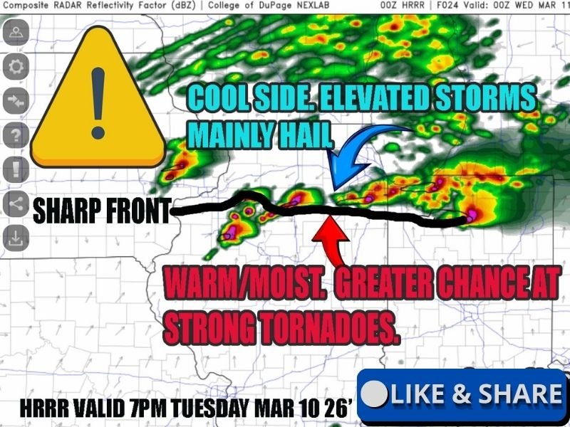
Forecasters say the most critical feature in the developing forecast is a very tight temperature and moisture boundary stretching across northern Illinois.
On one side of the boundary, cooler air from Lake Michigan could limit surface-based storms. On the other side, a much warmer and more humid air mass may allow storms to tap into extreme atmospheric instability.
Meteorologists say the atmosphere south of the boundary could contain CAPE values exceeding 3000, which represents a very high amount of storm energy for early March in the Midwest.
That level of instability can fuel strong updrafts capable of producing large hail, damaging winds, and rotating thunderstorms.
Tornado Risk Depends on Storm Position
The exact placement of storms relative to this boundary will likely determine how severe the threat becomes.
If storms remain on the cool side of the front, they may become elevated thunderstorms that primarily produce large hail.
However, if storms develop just south of the boundary within the warm and unstable air mass, the environment could support supercell thunderstorms capable of producing tornadoes.
Forecasters say the difference between these two scenarios may be only a few miles, making the setup particularly difficult to forecast.
Triple-Point Setup Could Increase Tornado Potential
Another concern in the forecast is the potential development of a surface low pressure system across Iowa, which could create a classic severe weather feature known as a triple point.
Triple points occur where multiple air masses collide and often serve as prime locations for intense storm development.
If the boundary shifts slightly north or remains firmly in place, storms interacting with this zone could rapidly intensify.
Meteorologists warn that in such scenarios strong tornadoes cannot be ruled out, especially if storms tap into the deepest warm and humid air.
Forecast Still Evolving
Despite the concerning ingredients appearing in forecast models, meteorologists emphasize that uncertainty remains high regarding how the boundary will behave.
Cooler air from Lake Michigan may push farther south than expected, which could reduce the tornado threat by keeping storms elevated.
However, even small shifts in the front’s position could dramatically change storm intensity.
Because of this, meteorologists say Tuesday’s setup will need to be watched closely as new forecast data becomes available.
Residents Urged to Stay Alert
With severe weather possible across portions of Illinois and Indiana Tuesday evening, residents are encouraged to stay aware of updated forecasts and be prepared for rapidly changing conditions.
Even if the overall severe threat remains uncertain, forecasters stress that it only takes one storm to produce dangerous conditions.
Stay with SaludaStandard-Sentinel.com for continued updates as meteorologists track this developing severe weather situation across the Midwest.