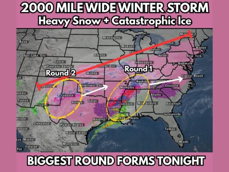
Historic Winter Storm Targets the Deep South With Record Snow in Oklahoma and a Crippling Ice Corridor From Texas to the Lower Mississippi Valley
UNITED STATES — A potentially historic winter storm is rapidly coming together and is expected to bring record-breaking snowfall and a dangerous, high-impact ice storm across parts of the Deep South and Southern Plains from Friday evening through Sunday. Forecast data shows this system developing quickly on radar as early as rush hour Friday, with impacts intensifying overnight and continuing through the weekend.
Meteorologists warn this setup combines deep Arctic air, strong lift, and Gulf moisture — a classic recipe for extreme winter weather in regions that rarely see it at this scale.
Oklahoma City Faces Record-Breaking Snowfall Potential
Forecast snowfall maps place central Oklahoma directly under the core of the storm, with Oklahoma City projected to receive 18 to 24 inches of snow if current trends hold.
That total would surpass the city’s all-time snowfall record of 13.2 inches, making this a once-in-a-generation winter event for the region. Surrounding areas, including Wichita, Dodge City, and Springfield, are also forecast to see significant accumulations ranging from 5 to 12 inches, with locally higher totals possible.
Snow is expected to fall heavily at times, reducing visibility to near zero and making travel extremely dangerous.
A Crippling Ice Storm Sets Up South of the Snow Line
While snow dominates the northern half of the storm, a major ice storm is forecast just south of the freezing line — a zone that often causes the most damage.
Ice accumulation forecasts indicate:
- 0.50 to 0.75 inches of ice across parts of North and East Texas
- Over 0.75 inches of ice possible from Texarkana through Shreveport, Monroe, Jackson, and into western Mississippi
- Widespread power outage risk due to ice loading on trees and power lines
Even 0.25 inches of ice can cause tree damage, but values approaching or exceeding three-quarters of an inch are capable of producing long-duration power failures and blocked roads.
Major Cities at Risk for Severe Impacts
Several large population centers sit directly in the impact zone, including:
- Oklahoma City
- Dallas–Fort Worth
- Austin and San Antonio
- Shreveport and Monroe
- Little Rock
- Memphis
- Jackson
In many of these areas, winter infrastructure is limited, increasing the likelihood of prolonged disruptions.
Timing and Rapid Intensification
The storm is expected to:
- Begin developing Friday evening
- Strengthen rapidly overnight
- Reach peak intensity Saturday
- Continue impacting parts of the region through Sunday
Because of the storm’s speed and intensity, conditions may deteriorate much faster than usual, leaving little time for last-minute preparation.
Why This Storm Is Especially Dangerous
This system is particularly concerning because it delivers multiple high-impact threats at once:
- Record snowfall in the Southern Plains
- A widespread, damaging ice storm to the south
- Sub-freezing temperatures that limit melting
- The potential for multi-day power outages
Officials urge residents to prepare for extended periods without electricity, limited travel, and rapidly changing conditions. As forecasters continue documenting this evolving storm, updates will remain critical.
Stay with SaludaStandard-Sentinel.com for ongoing coverage, refined snowfall and ice totals, and region-by-region impact updates as this historic winter storm unfolds.