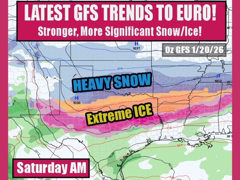
High-Impact Winter Storm Signal Strengthens as GFS Aligns With Euro, Raising Risk of Heavy Snow and Extreme Ice From Texas Into the Mid-South
UNITED STATES — Confidence is increasing that a high-end, impactful winter storm may develop across a large portion of the central and southern United States as the latest GFS model has shifted toward the EURO solution, a key signal meteorologists watch closely when assessing storm potential.
With multiple model cycles now converging, the window for this system to weaken is shrinking. If current trends hold over the next 24 hours, forecast messaging will likely need to escalate as impacts could be significant to severe, particularly for areas prone to ice.
Why the GFS Trending Toward the Euro Matters
In winter forecasting, agreement between the GFS and ECMWF (Euro) often marks a turning point. Historically, when the GFS “caves” toward a consistent Euro solution, it signals that large-scale atmospheric features are becoming locked in.
Current guidance now supports:
- A strong Arctic air mass already in place
- A powerful storm system riding along the temperature boundary
- A prolonged window for snow north of the track and significant ice to the south
This alignment dramatically increases confidence in a high-impact event rather than a minor system.
Heavy Snow Axis vs. Extreme Ice Zone
Model depictions show a classic high-risk setup:
- Heavy snow likely developing on the cold side of the storm, potentially affecting parts of the southern Plains into the mid-Mississippi Valley
- A dangerous extreme ice corridor setting up farther south, where warm air aloft overruns surface-level Arctic air
Ice accumulation is often the most disruptive winter hazard in the South, and current guidance suggests freezing rain could be the dominant precipitation type in some areas rather than snow.
Texas and the Southern Plains: A Region to Watch Closely
North Texas and nearby regions sit uncomfortably close to the projected ice zone. With surface temperatures locked below freezing and moisture increasing aloft, even small track shifts could result in widespread icing, power outages, and travel shutdowns.
Preparations are already underway in parts of Texas, and residents across the broader threat area should take this system seriously given the potential for long-lasting impacts.
Timing and Confidence Outlook
While exact snowfall and ice totals remain uncertain, the synoptic pattern—the large-scale atmospheric setup—is becoming increasingly clear. This is the type of storm that rarely disappears at the last minute once models converge this strongly.
Over the next 24 hours:
- Confidence will either increase rapidly or trend downward
- If trends remain steady, official warnings and advisories will likely follow
What Residents Should Do Now
Even ahead of final details, now is the time to prepare:
- Review winter travel and power outage plans
- Stock essentials in case roads become impassable
- Stay alert for forecast updates and official advisories
This has the potential to be a remember-it-for-years winter storm for parts of the central and southern U.S. Forecast confidence is rising, not falling.
Continue following updates and in-depth winter weather coverage at SaludaStandard-Sentinel.com, where we’ll track every major development as this high-impact storm evolves.