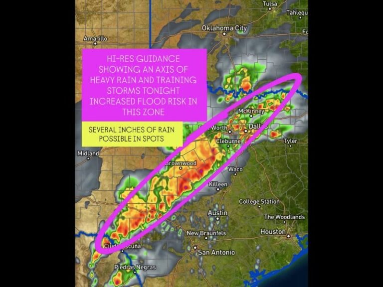
Heavy Snowstorm to Bring Up to 8 Feet of Snow Across California, Nevada, Utah, and Idaho Through Friday
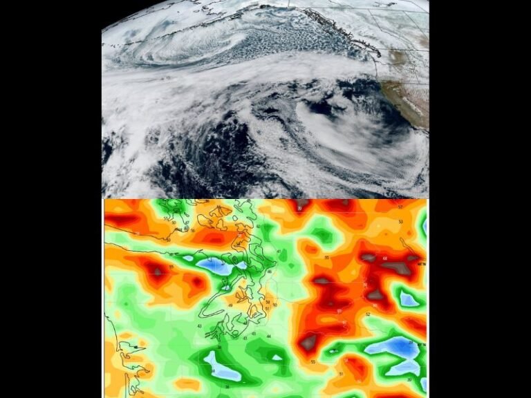
CALIFORNIA — A major winter storm is sweeping across the western United States, delivering dangerous snowfall totals that could reach up to 8 feet in the highest mountain ranges by Friday evening. The system is bringing widespread travel disruptions, hazardous mountain conditions, and significant snowpack increases across California, Nevada, Utah, Idaho, and surrounding states.
Sierra Nevada Bracing for the Heaviest Snowfall
The Sierra Nevada will see the most extreme impacts from this system. Forecast models show 4–8 feet of snow expected through Friday night in the highest elevations. Lower elevations and surrounding regions will still see 1–3 feet, with intense snow bands expected to create whiteout conditions.
Central California mountains are also projected to receive up to 3 feet of snow, making travel along mountain passes especially dangerous. Chain requirements, highway closures, and avalanche concerns are expected as snow continues to intensify.
Nevada Mountains to See Widespread High-Impact Snow
Significant snowfall is forecast across Nevada’s higher terrain, particularly near Reno, Elko, and the central mountain corridors. Snowfall totals include:
• 1–3 feet through Friday evening in northern Nevada
• 2–8 inches in central Nevada by Friday morning
• Steady snow accumulation across ski regions and backcountry areas
Cold air over the state will allow snow to accumulate quickly, worsening road conditions and reducing visibility.
Utah’s High Elevations Facing Heavy Accumulation
Utah will experience substantial snowfall across its major mountain ranges. Expected totals include:
• 6–12 inches from Friday afternoon through Sunday
• 15–20 inches in isolated high peaks such as the Uintas, Tushars, and Cottonwoods
• Heavy bursts of snow during peak hours creating travel slowdowns across canyons and mountain highways
Avalanche danger is expected to rise throughout the weekend as deep new snow layers increase the instability of the snowpack.
Idaho and Wyoming to Receive Widespread Winter Impacts
Idaho’s mountain regions will see 3–12 inches of snow between Friday morning and Saturday. Higher elevation zones and ski corridors near Boise will likely receive the most accumulation.
Wyoming will see 6–15 inches, with some northeastern areas expecting 8–18 inches, especially from Friday evening through Saturday.
Snowfall across these regions is expected to contribute positively to winter snowpack but will also cause challenging travel conditions.
Travel and Safety Concerns Across Western States
Officials warn residents and holiday travelers across the region to prepare for:
• Rapidly deteriorating road conditions
• Whiteout visibility near mountain passes
• Chain controls likely on major routes
• Backcountry avalanche risk increasing through the weekend
• Possible delays at ski resorts and mountain access points
The storm arrives during a peak holiday travel window, increasing the likelihood of traffic delays and road closures. Residents are encouraged to monitor local forecasts, avoid unnecessary mountain travel, and prepare for winter hazards as the storm continues through Friday. For ongoing updates, visit SaludaStandard-Sentinel.com.