Heavy Rainfall to Drench the Gulf Coast From Thursday Through Friday, Bringing 3–5 Inches to Louisiana, Mississippi, and Alabama
MOBILE, AL — The Gulf Coast is bracing for a major soaking as a slow-moving rain system is expected to dump 3 to 5 inches of rain across parts of Louisiana, Mississippi, and Alabama from Thursday through Friday evening, raising concerns about flash flooding, poor visibility, and travel disruptions across the region.
Meteorologists say the storm’s moisture-rich air mass will linger along the coast for several days, keeping conditions soggy through the end of the week.
Up to 5 Inches of Rain Possible Along the Central Gulf Coast
According to data from WeatherBell Analytics, rainfall totals are projected to range between 3.5 and 4.5 inches across southern Louisiana and coastal Mississippi, with New Orleans, Gulfport, Biloxi, and Mobile among the hardest-hit areas.
Some isolated pockets could receive more than 5 inches, particularly in regions where storms repeatedly move over the same area — a phenomenon known as training.
The heaviest rainfall is expected between Thursday afternoon and Friday evening, when thunderstorms and torrential downpours will develop along the Gulf Coast corridor.
“Residents from Baton Rouge to Pensacola should prepare for localized flooding, water over roadways, and ponding in low-lying areas,” forecasters said. “Avoid driving through flooded roads, and stay alert for rapid water rises.”
New Orleans and Mississippi Coast Prepare for Flooding Risk
The city of New Orleans could see up to 4 inches of rain, creating challenges for drainage systems already taxed by persistent rainfall earlier this week. Coastal Mississippi and Alabama will face similar issues as saturated ground heightens the risk of street flooding and standing water.
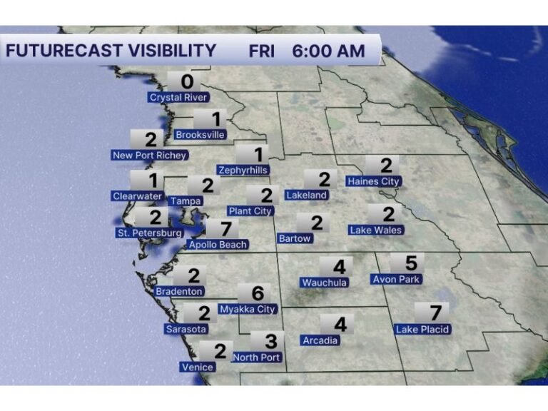
Rainfall intensity could reach 1 to 2 inches per hour at times, making commutes and travel hazardous. Officials are urging residents in flood-prone neighborhoods to move vehicles to higher ground and clear drains before the heaviest rain arrives.
Severe Weather Risk Remains Low, But Flooding Is the Main Concern
While this storm system is not expected to bring widespread severe weather, embedded thunderstorms may produce bursts of gusty wind or isolated lightning strikes. The main threat, however, will be from prolonged, heavy rainfall and poor drainage flooding.
The National Weather Service has issued Flood Watches for parts of southeastern Louisiana, southern Mississippi, and southwest Alabama, warning that conditions could deteriorate quickly, especially in urban areas.
Travel Impacts Expected Across the Region
Motorists along Interstate 10 and Highway 90 should prepare for reduced visibility, hydroplaning hazards, and temporary road closures due to high water.
Authorities advise drivers to avoid low-lying routes, particularly in coastal areas like Grand Bay, Pascagoula, and Gulf Shores, where heavy runoff can make roads impassable.
“If you park low, don’t,” one forecaster warned humorously, adding that residents should “treat this system seriously — it’s not just a light rain event.”
Rain to Ease by Late Friday Night
The good news: forecasters expect the rain to gradually taper off by late Friday night into early Saturday, as the system drifts eastward toward Florida and the southeastern Atlantic coast.
Behind the rain, cooler and drier air will begin filtering in, bringing a brief reprieve for the weekend.
However, any additional rainfall next week could lead to renewed flooding concerns, as the saturated ground will struggle to absorb more water.
Residents across the Gulf Coast are urged to monitor local forecasts and avoid unnecessary travel during peak rainfall periods through Friday evening.
For continued updates on Gulf Coast weather alerts, visit SaludaStandard-Sentinel.com for the latest reports and advisories.