Heavy Rainfall and Flooding Threat Expands Across Gulf Coast, Mississippi, Alabama, Georgia, and the Carolinas Through Tuesday
BIRMINGHAM, ALABAMA — A powerful late-autumn rain system is soaking the Southeast and Gulf Coast states, with meteorologists warning of 1 to 3 inches of rainfall — and even higher totals in some areas — between now and Tuesday night.
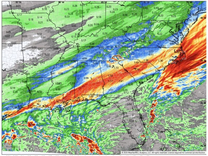
The latest NAM 3-km precipitation model shows a vivid band of heavy rain stretching from eastern Texas and southern Louisiana through Mississippi, Alabama, Georgia, and the Carolinas, before sliding off the East Coast by Wednesday morning.
Forecasters say the system will deliver relentless rounds of rain, gusty winds, and water-logged conditions that could cause ponding on roads, low-lying flooding, and dangerous travel across multiple states.
Widespread Soaking Across the South
Communities from Mobile to Tallahassee are expected to face the heaviest rainfall, while areas farther north — including Jackson, Birmingham, Atlanta, and Columbia — will also experience prolonged downpours.
Some spots along the central Gulf Coast could receive over 3 inches of rainfall, leading to localized flooding. Even regions that don’t see flash flooding may experience saturated soil, slick roads, and standing water hazards.
“This is the kind of rain where even your dog refuses to go outside,” joked one local meteorologist. “Expect continuous rain through Tuesday night with few breaks.”
Mississippi, Alabama, and Georgia Under the Heaviest Band
Forecast models highlight Mississippi and Alabama as the core of this rainfall event. Cities like Meridian, Montgomery, and Birmingham could see consistent moderate to heavy rainfall lasting more than 24 hours.
In Georgia, the heaviest totals will likely fall north and west of Atlanta before shifting east into the Carolinas late Tuesday. North and South Carolina can expect heavy showers and potential flash flooding as the system exits the region.
“We’re seeing one of the more widespread heavy-rain setups of the season,” a regional forecaster said. “The saturated air mass is feeding directly from the Gulf of Mexico, which is keeping this system energized.”
Drivers Urged to Use Caution
Officials across several states are urging drivers to take extra precautions during the storm. With persistent rain expected for nearly two days, visibility will drop significantly, and slick conditions will be common across interstates and rural highways.
Motorists are advised to slow down, use headlights, and avoid driving through standing water, which can be deeper than it appears. Urban areas such as New Orleans, Jackson, Birmingham, and Atlanta are especially prone to street flooding due to poor drainage.
Localized Flooding and Urban Impacts
Rainfall totals of 1–3 inches may not seem extreme, but when concentrated over a short period, they can quickly lead to urban and flash flooding, especially in areas that have already received rain in recent days.
The Weather Prediction Center (WPC) has outlined a marginal to slight risk for excessive rainfall across parts of the Deep South and Southeast, meaning isolated flooding events are possible.
Communities in southern Alabama, the Florida Panhandle, and coastal Mississippi could see the most significant flooding impacts.
Lingering Showers Midweek
The storm system is expected to push toward the Atlantic coast late Tuesday night, bringing heavy rain to the Carolinas and coastal Virginia before finally tapering off by Wednesday morning.
Behind the system, forecasters expect cooler, drier air to move in, offering relief after a soggy and stormy start to the week.
Residents are encouraged to monitor local forecasts and weather alerts, particularly in flood-prone or low-lying areas.
For the latest updates on rainfall totals, flooding alerts, and severe weather coverage across the South, stay with SaludaStandard-Sentinel.com — your trusted source for accurate weather and community news.