Heavy Rain Floods New Orleans, Mississippi, and Alabama Gulf Coast as Nearly 3 Inches Fall in Six Hours
NEW ORLEANS, LA — A powerful band of heavy rain has drenched New Orleans, southern Mississippi, and coastal Alabama, dumping nearly three inches of rainfall in just six hours and causing widespread street flooding across the Gulf region. The downpour, which began late Monday night, quickly overwhelmed drainage systems, turning neighborhoods into temporary ponds and making travel difficult.
Flash Flooding Strikes the Gulf Coast
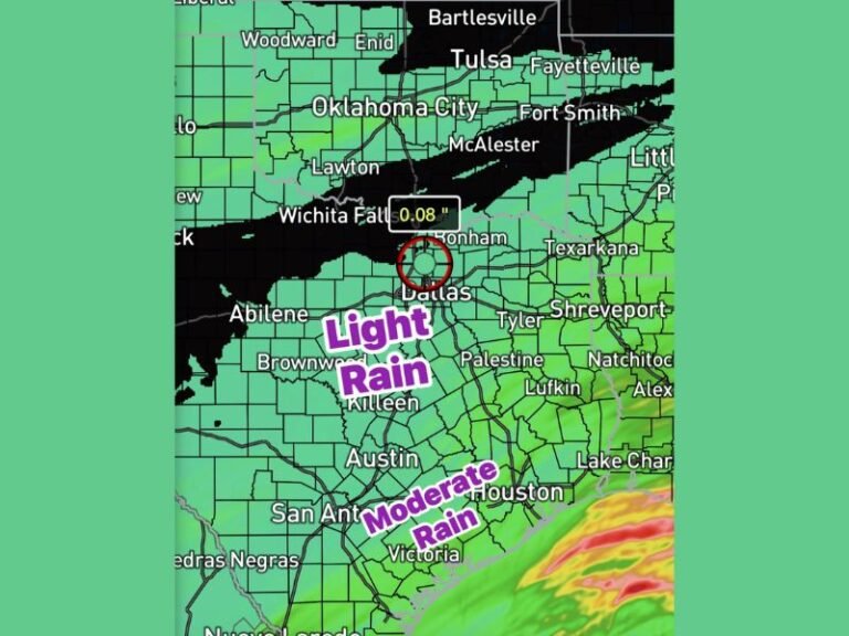
Meteorologists reported that rainfall rates exceeded one inch per hour across parts of the New Orleans metro area, prompting flash flood advisories from the National Weather Service. Radar data shows a nearly stationary line of storms stretching from Baton Rouge to Mobile, with heavy pockets of rain continuing to move inland toward Jackson and Montgomery.
In some coastal communities, residents described the situation as “swamp-like,” with driveways and ditches overflowing and roads becoming nearly impassable. Grand Bay, Alabama, recorded about 2.5 inches of rain, adding to the growing list of flooded areas along the Gulf Coast.
Neighborhoods Report Flooded Streets and Deep Potholes
Locals across southeast Louisiana shared that water was covering driveways, front yards, and even portions of residential streets. In some cases, potholes filled with water so deep that they resembled small ponds. One observer humorously compared the scene to “a deluxe swamp package with extra gators included.”
The persistent rainfall has saturated the soil, leaving areas vulnerable to additional flooding if more storms develop overnight. Public works crews in New Orleans have been clearing storm drains and debris in an effort to prevent further water buildup.
Meteorologists Expect Rain to Continue Through Tuesday
Weather radar from the National Weather Service shows multiple rain bands stretching from Houston to the Alabama coastline, with additional showers expected to redevelop throughout Tuesday. While rainfall totals are expected to taper off by midweek, temperatures will drop sharply behind the front, ushering in cooler and drier air for the Gulf Coast.
Forecasters say the combination of heavy rain followed by cold air could make for slippery conditions on bridges and elevated roads early Wednesday morning. Drivers are urged to slow down, avoid flooded areas, and never attempt to cross standing water.
Residents Express Frustration Over Repeated Flooding
Many New Orleans residents voiced frustration over repeated street flooding that has become all too familiar in recent years. Social media users described scenes of potholes resembling deep-sea fishing zones and joked that the city’s drainage system was “filing for bankruptcy.”
Despite the humor, officials remind residents to stay cautious, as additional rainfall could quickly worsen conditions before the storm system moves east.
If you’ve experienced flooding or damage from this Gulf Coast storm, share your story with us at SaludaStandard-Sentinel.com.


