Heavy Rain and Localized Flooding Threatening Western North Carolina Tuesday While Central and Eastern Areas Heat Up to the Low 90s Under Partly Sunny Skies
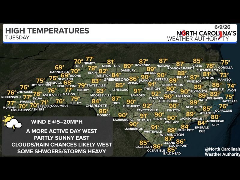
ASHEVILLE, NC — North Carolina is split into two distinct weather stories Tuesday, June 9, with western mountain and foothill communities facing ongoing scattered showers, periods of heavy rainfall, and localized flooding risk through the day, while central and eastern portions of the state enjoy mostly dry conditions and temperatures climbing into the low 90s.
Western North Carolina Rain and Flood Threat
The mountains and foothills of western North Carolina will bear the most active weather Tuesday, with scattered showers and thunderstorms expected on and off throughout the day. Periods of heavy rainfall are likely, particularly across southwestern mountain communities where localized flooding is a genuine concern in valleys, creek bottoms, and areas with poor drainage.
Temperatures across the western counties will remain in the 70s, with Asheville topping out near 78°F, Murphy at 77°F, and higher elevation communities like Banner Elk and Boone holding in the upper 60s to low 70s. Mostly cloudy skies will persist across the western half of the state throughout the day.
Central and Eastern Heat Building
East of the mountains, the picture changes dramatically. Central North Carolina will see highs climbing into the upper 80s to low 90s, with Raleigh reaching 91°F, Fayetteville hitting 92°F, and Pinehurst topping out at 92°F as well. Greensboro will reach 83°F and Charlotte climbs to 84°F under partly sunny skies with only isolated storm chances.
Eastern communities including Kinston, Goldsboro, and Wilson will push into the 90 to 92°F range, while coastal areas from Wilmington through the Outer Banks remain in the mid to upper 70s with sea breeze influence keeping conditions more comfortable along the shoreline.
Wind and Conditions Statewide
Easterly winds at 5 to 20 mph will flow across the state Tuesday, helping push moisture into the mountains and foothills from the east while keeping coastal areas relatively comfortable. The wind pattern reinforces the west-east weather divide that will define the day across North Carolina.
Residents in the southwestern mountains should avoid flood-prone roads and monitor stream levels through the afternoon as heavy rain episodes could produce rapid rises in waterways. For continuing coverage of North Carolina weather and flood threats across the United States, visit SaludaStandard-Sentinel.com.