Gulf Coast Weather Models Hint at Low Chance of Frozen Precipitation Saturday Night, but Guidance Shows Limited Cold Air for Any Impact
TEXAS — Weather guidance shows a low-end chance of frozen precipitation along portions of the Gulf Coast late Saturday night into early Sunday, but early indications suggest that temperatures may not be cold enough for anything impactful. Forecasters emphasize that while the possibility exists, the setup remains uncertain and the risk is currently considered very low.
Models Suggest a Small Window for Frozen Precipitation
According to the forecast discussion, some guidance indicates the potential for “frozen stuff falling from the sky” sometime between late Saturday and early Sunday. The scenario remains highly conditional, depending on whether cold air and moisture can overlap at the same time — a combination that is typically challenging along the Gulf Coast.
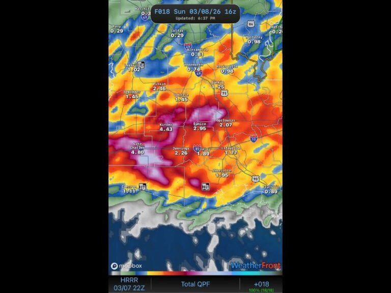
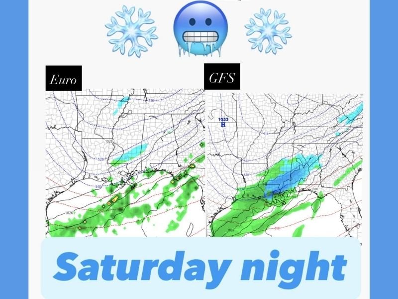
The Euro and GFS comparison maps included in the discussion highlight two different interpretations:
- The Euro model shows only a small area of frozen precipitation, with most moisture staying south of the colder air.
- The GFS model displays a broader area of wintry precipitation stretching across parts of the region, but still dependent on exact temperature profiles.
Both models illustrate why confidence remains low: the timing, moisture depth and temperature alignment all remain uncertain.
Forecasters Note Low Confidence in Meaningful Impacts
The update makes it clear that the chance of anything significant is currently very low, and temperatures “don’t look cold enough for meaningful impacts.”
Experts also caution residents not to get carried away by early social media posts or exaggerated claims, noting that the Gulf Coast historically struggles to line up the ingredients needed for frozen precipitation. Even if frozen precipitation were to occur, the early signal suggests it would likely be brief, light and limited in coverage.
Cold Air and Moisture Must Align Perfectly — and That Rarely Happens Along the Gulf Coast
One of the key challenges mentioned in the discussion is the difficulty of getting cold air and moisture in place simultaneously along this part of the country. Moisture often arrives too early or too late, and temperatures struggle to fall quickly enough.
This aligns with the message that while the situation is “worth watching,” residents should not get excited about it yet. The focus remains on monitoring how much moisture will be available and how cold temperatures ultimately get as the weekend approaches.
Updates Expected as Forecast Refines Ahead of the Weekend
Forecasters will continue reviewing model runs and temperature trends as the weekend gets closer. The situation may shift depending on evolving moisture patterns or colder-than-expected air arriving late Saturday.
The Saluda Standard-Sentinel will provide updates as new data becomes available and confidence in the forecast improves. Readers are invited to share whether they are seeing early winter weather chatter in their communities at SaludaStandard-Sentinel.com.