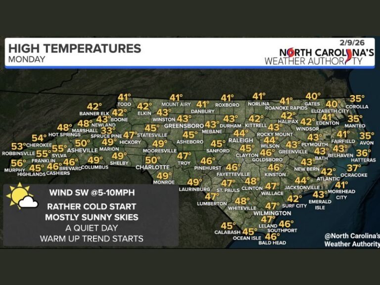
Growing Snow Signal for Valentine’s Day Weekend as European Model Shifts Storm Track South and Strengthens Cold Side
UNITED STATES — A developing winter weather signal is drawing attention as new European forecast model data shows a storm system shifting farther south, increasing the cold side of the setup and raising the possibility of snow next weekend.
The trend has now appeared in three consecutive European model runs, a sign that forecasters say is worth monitoring, even though the forecast remains far from finalized.
European Model Shifts Storm Track South
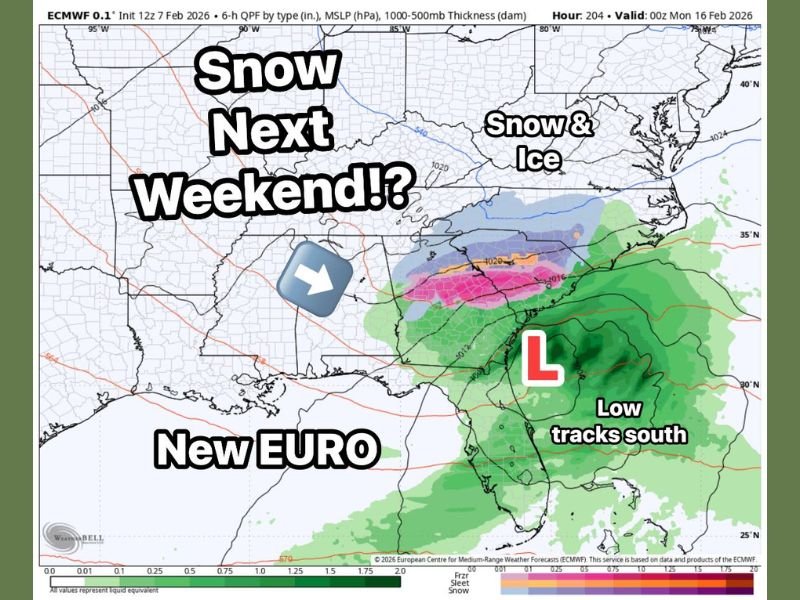
The latest ECMWF guidance shows the storm track backing farther south compared to earlier runs. This shift reduces the influence of warmer air and increases the likelihood that colder air could be in place as precipitation moves through the region.
A more southern track is critical because it opens the door for snow instead of rain, depending on how temperatures evolve closer to the event.
Valentine’s Day Weekend Timing Raises Impact Concerns
Current timing places the system during Saturday into Sunday of Valentine’s Day weekend, which could affect travel, outdoor plans, and holiday events if winter weather materializes. Forecast visuals show a low-pressure system tracking south, with a zone of snow and ice developing north of the storm’s center.
Snow and Ice Possible on the Cold Side of the System
Model output highlights a band of snow and ice on the northern edge of the storm, while heavier rain remains closer to the low itself. Small changes in storm position could shift where rain ends and snow begins.
At this stage, exact locations and accumulations cannot be determined, but the signal is becoming clearer with each run.
Forecast Still Uncertain, But Trend Worth Watching
Forecasters stress that this setup is not locked in, and there is still time for significant changes. However, the consistency in recent model runs suggests the pattern is one residents should pay attention to as the week progresses.
Additional data over the coming days will help clarify whether this system becomes a true winter weather event or remains a near-miss.
We will continue tracking this evolving forecast closely. If you’re watching this system or planning travel next weekend, share your thoughts with us at SaludaStandard-Sentinel.com, where we focus on accurate, data-driven weather coverage for South Carolina and beyond.