Great Lakes and Northeast States See 90–100% Snow Chances While Arctic Cold Air Sinks South Toward Florida
UNITED STATES — A persistent winter weather pattern is setting up across the country, with the highest chances for accumulating snow over the next 10 days focused on the Great Lakes and the Northeast, according to ensemble forecast guidance tracking conditions through late January.
Snow Chances Remain Elevated Through Jan. 21
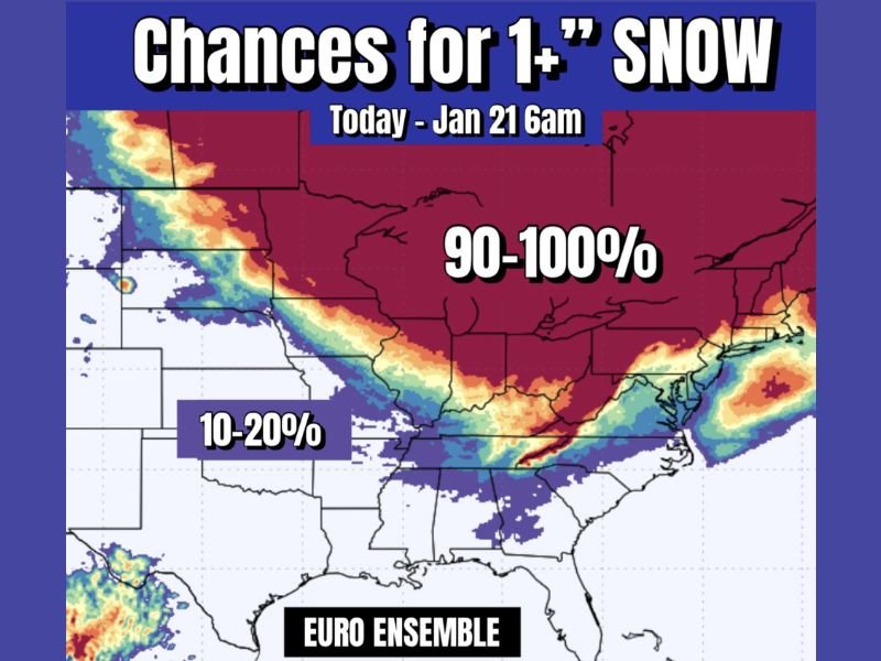
Forecast probability maps show a 90 to 100 percent chance of at least one inch of snow across much of the Upper Midwest, Great Lakes region, and interior Northeast through the January 21 timeframe. This signals a highly favorable setup for repeated snow opportunities rather than a single storm event. The snow-favored zone stretches from portions of the northern Plains through the Great Lakes and into New England, indicating that winter will remain active and consistent across these regions.
Why the Pattern Is Sticking
Meteorologists point to a locked-in cold pattern as the primary driver. Repeated injections of colder air are keeping temperatures low enough to support snow whenever moisture moves through. Instead of storms tracking well north or south, systems are repeatedly crossing areas where cold air is already established.
This type of pattern increases confidence in snow chances even when individual storm tracks remain uncertain several days out.
Lower Probabilities to the South — For Now
Farther south, including parts of the southern Plains and lower Mississippi Valley, snow probabilities remain much lower — generally in the 10 to 20 percent range. However, forecasters caution that this could change if colder air continues pushing southward later in the month. With colder air expected to sink as far south as Florida during the second half of January, snow chances could expand southward if storm systems align with the colder air mass.
Great Lakes and Northeast Remain the Bullseye
For now, the Great Lakes and Northeast remain the most reliable areas for snow. Lake-enhanced snow, clippers, and coastal systems all remain in play as the jet stream continues to favor these regions. While not every location will see heavy snow, the persistence of the pattern increases the likelihood of multiple snow events, gradual snowpack buildup, and repeated travel disruptions.
What to Expect Going Forward
Forecasters emphasize that snow probabilities do not guarantee a major storm, but they do indicate frequent opportunities for snow. Residents in high-probability zones should plan for changing road conditions, continued winter maintenance needs, and potential delays as January progresses.
Are you already dealing with snow where you live, or still waiting for winter to arrive? Share your local conditions and thoughts on the evolving forecast with readers at SaludaStandard-Sentinel.com.