GFS Model Shows Extreme Christmas Day Temperature Split Across North Dakota, Minnesota, Montana, Wisconsin, Texas, Louisiana, Mississippi, Alabama, Georgia, and Florida
UNITED STATES — New long-range GFS model data reveals a dramatic temperature divide on Christmas Day, with dangerous Arctic cold gripping North Dakota, Minnesota, Montana, and Wisconsin, while Texas, Louisiana, Mississippi, Alabama, Georgia, and Florida remain unseasonably warm. The updated run shows a major correction from earlier forecasts, reinforcing the importance of watching broad weather patterns rather than daily model fluctuations.
Northern States Brace for Severe Arctic Cold
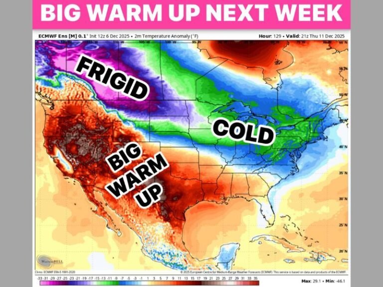
The latest GFS temperature map shows brutally cold conditions across the Northern Plains and Upper Midwest.
Temperatures are projected to fall into the -20°F to -30°F range in Montana and North Dakota, with single digits and teens across Minnesota and Wisconsin. The cold pool extends through the Great Lakes, marking one of the harshest model depictions so far for the holiday period.
Meteorologists note that earlier projections of a widespread warm spell have now shifted significantly. As the broader atmospheric pattern settles, the model shows a reinforced Arctic surge dominating the northern tier of the country.
Southern States Hold Onto Warm, Spring-Like Conditions
Meanwhile, the southern half of the country paints a very different picture. Forecast temperatures across Texas, Louisiana, Mississippi, Alabama, Georgia, and Florida climb into the 60s and 70s, creating an unusually warm holiday stretch for millions of residents.
This sharp contrast highlights a well-defined national temperature boundary. Warm Gulf and subtropical air remain firmly in place across the South, while the Arctic front stalls farther north, preventing cold air from fully penetrating deep into the region.
Pattern Shift Shows Why Long-Range Forecasts Require Caution
Meteorologists emphasize that this correction is an example of how small upper-air changes can lead to big surface-level temperature differences. Long-range models frequently fluctuate, but the larger-scale pattern ultimately determines the outcome.
The current trend validates earlier signals suggesting colder northern conditions for late December. The newly adjusted model now aligns more closely with that broader pattern, reinforcing why experts urge caution when reacting to single model runs.
The December 25 outlook now shows a nation divided between dangerous cold in the north and unseasonably warm conditions in the south, marking a rare and striking holiday temperature split.
Residents preparing for Christmas Day or monitoring developing weather changes are encouraged to share their observations with the community at SaludaStandard-Sentinel.com.