GFS and European Models Split on Potential MLK Weekend Snow Event as Arctic Air Pushes In but Storm Track Remains Uncertain
UNITED STATES — Forecasters are closely watching a developing winter pattern as Arctic air spreads southward and computer models diverge on whether a significant snow event could materialize around the Martin Luther King Jr. weekend, or remain limited in scope due to storm track issues.
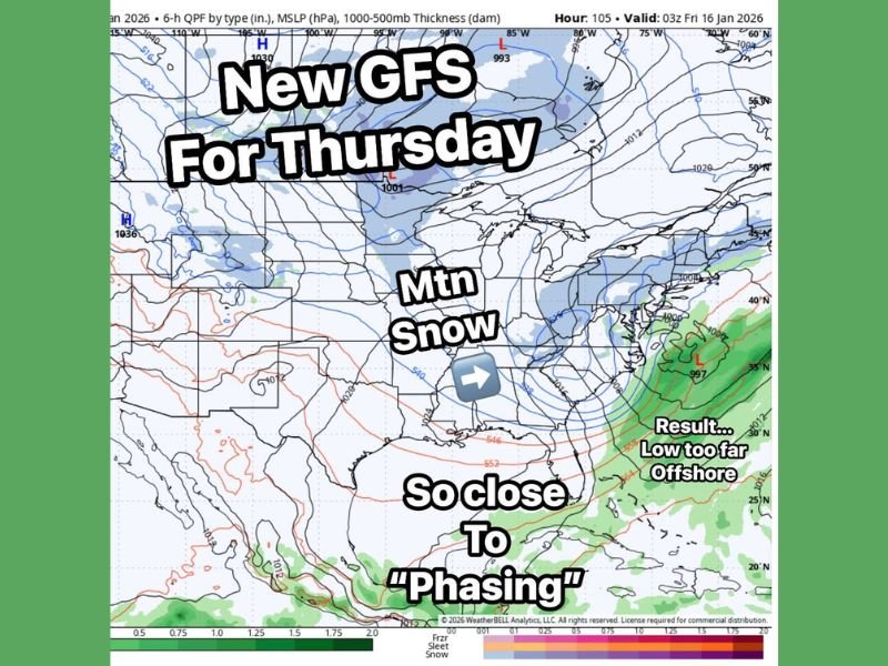
Thursday System Comes Close but Misses Major Impacts
The latest Global Forecast System (GFS) data shows how close the upcoming Thursday system came to becoming a high-impact winter storm. While cold Arctic air is firmly in place, the northern jet stream arrives too early, forcing the surface low pressure system too far offshore.
That shift prevents Atlantic moisture from feeding back into the cold air, a key ingredient needed for widespread snow. As a result, snowfall impacts are expected to remain largely confined to mountainous regions, rather than expanding inland across broader population centers.
Why Phasing Matters for Big Snow Events
Meteorologists emphasize that major winter storms often rely on proper “phasing” — when northern and southern jet streams align at the right time and location. In the Thursday setup, that alignment fails to occur, limiting snowfall potential despite otherwise favorable cold air conditions.
Forecast maps show strong pressure gradients and moisture just offshore, underscoring how small timing differences can dramatically change outcomes.
MLK Weekend Emerges as the Next Key Window
Attention is now turning to the Saturday–Sunday and MLK weekend timeframe. The morning GFS run indicates that phasing may occur later, potentially producing a more impactful system capable of delivering 4 to 8 inches of snow across parts of the region.
However, the European model (ECMWF) remains far less aggressive, maintaining a pattern similar to Thursday’s setup — cold, but with moisture largely missing the inland areas.
Model History Adds to Uncertainty
Adding complexity, forecasters note that the GFS previously showed a major snow event for Thursday before eventually backing off and aligning with the European solution. The key question now is whether the GFS will once again trend weaker, or if confidence will grow in a more widespread MLK weekend snow scenario. This type of model disagreement is common several days out, especially during dynamic winter patterns involving Arctic air intrusions.
Arctic Pattern Likely to Persist
Regardless of storm outcomes, meteorologists agree that the overall winter pattern is strengthening. Repeated cold shots, mountain snow, and multiple opportunities for winter weather are expected as January progresses.
Residents are encouraged to monitor forecast updates closely, particularly as higher-confidence data becomes available later this week. Do you think the MLK weekend storm will finally phase correctly, or miss again? Share your thoughts and local expectations with readers at SaludaStandard-Sentinel.com.