Georgia Winter Pattern in January 2026 Echoes 1996 Setup as Arctic Air and Jet Stream Shift Raise Cold Weather Concerns
GEORGIA — Meteorologists analyzing the January 2026 weather pattern are increasingly drawing comparisons to the historic winter of 1996, not because a major snowstorm is guaranteed, but because the large-scale atmospheric setup shows striking similarities that once produced widespread disruption across the eastern United States.
While 1996 is best remembered for the “Blizzard of ’96” in the Northeast, Georgia’s experience that winter was driven by the same powerful atmospheric mechanics now appearing again nearly 30 years later. The concern this time is not hype, but how timing, moisture, and Arctic air placement could align across the Southeast as January progresses.
Sudden Stratospheric Warming Is Driving the Pattern Change
One of the strongest similarities between January 1996 and January 2026 is the presence of a Sudden Stratospheric Warming (SSW) event.
In early January 1996, a major split in the polar vortex allowed Arctic air to spill southward into the Deep South. Georgia experienced a transition event on January 7–8, when heavy rain changed to ice and light snow as cold air undercut moisture.
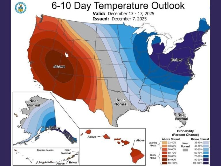
In January 2026, meteorologists are observing a nearly identical stratospheric split, with cold air expected to take 10–14 days to descend from the upper atmosphere into the lower troposphere. This delay means Georgia may see abnormally warm weather first, followed by a sharp temperature crash later in the month. This delayed arrival of cold air is a key signal, not an immediate forecast.
Weak La Niña Adds Volatility to Georgia’s Weather
Both winters are also influenced by a weak La Niña, which historically leads to a highly variable jet stream.
For Georgia, this means:
- Short bursts of unusual warmth
- Followed by sudden, aggressive cold snaps
- Increased difficulty in predicting exact outcomes days in advance
In 1996, this pattern culminated in “The Great Freeze” in early February, when North Georgia temperatures dropped into the single digits. Current January 2026 ensemble models are hinting at a similar late-month temperature collapse, though no specific storm is confirmed.
Why January 2026 Could Impact Georgia Differently
There are also important differences that could work either for or against Georgia this time. In 1996, the best moisture alignment occurred farther north, leaving Georgia with mostly cold rain and brief wintry mix instead of heavy snow.
In 2026, the Pacific-North American (PNA) index is trending more positive, which typically pushes the jet stream farther south. This raises the possibility — not a forecast — that the rain-snow transition line could dip closer to the I-20 corridor if moisture arrives at the right moment. Meteorologists stress this is a pattern comparison, not a storm prediction.
What Georgians Should Take From This Comparison
The takeaway is not panic, but awareness.
January 2026 is showing the same atmospheric “engine” that powered one of the most disruptive winters in modern history, even if the final outcomes differ. Residents should be prepared for:
- Rapid temperature swings
- Potential freezing rain or sleet scenarios
- Short-notice winter weather impacts
As always, specific impacts will depend on timing, and forecasts will sharpen closer to any event.
For now, experts emphasize one thing clearly: the current pattern deserves attention, not dismissal, especially for Georgia residents accustomed to winter surprises arriving after periods of warmth. Stay informed and follow continued updates from SaludaStandard-Sentinel.com as meteorologists refine the outlook.