Georgia Storm Emergency: Severe Thunderstorm Warning With “Tornado Possible” Tag Issued for Atlanta Area as Damaging Winds and Rotation Detected
GEORGIA — A dangerous line of severe thunderstorms is moving across parts of north Georgia late tonight, prompting a severe thunderstorm warning with a “tornado possible” tag for areas around Atlanta and communities to the west as meteorologists track signs of rotation within the storm system.
Weather radar shows intense storms stretching from Alabama into western Georgia, pushing toward the Atlanta metro region with heavy rain, damaging winds, and embedded rotation that could quickly lead to a tornado warning if conditions worsen.
Storm Line Pushing Toward Atlanta
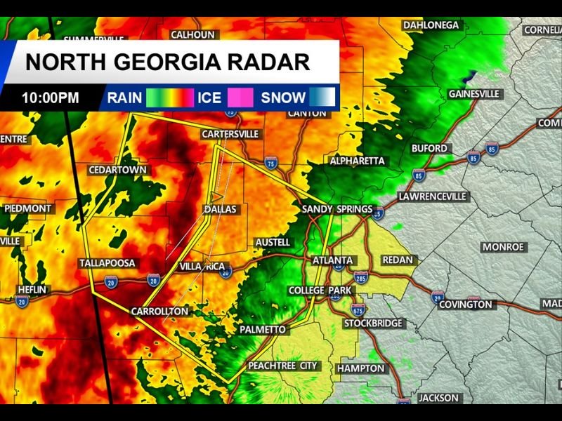
The strongest storms are currently located west of Atlanta, impacting communities including Cedartown, Dallas, Carrollton, and Villa Rica, where radar imagery shows powerful thunderstorms producing extremely heavy rainfall and strong wind gusts.
Forecasters say the storm line is gradually advancing eastward toward Austell, Sandy Springs, College Park, and the greater Atlanta metro area. As of the latest radar update around 10:00 p.m., the storm system has already intensified enough for officials to issue a severe thunderstorm warning covering much of Atlanta and surrounding counties.
Rotation Detected Inside the Storm Line
Meteorologists monitoring the system report that instances of rotation have been detected along the leading edge of the storm line, which triggered the addition of the “tornado possible” tag within the severe thunderstorm warning.
While a tornado has not yet been confirmed, the presence of rotation means conditions could change quickly if a stronger circulation develops within the storms. Residents across the warning area are being urged to remain alert and be prepared to seek shelter immediately if a tornado warning is issued.
Damaging Winds and Intense Rainfall
Even without a confirmed tornado, the storm system is capable of producing dangerous conditions.
Forecasters warn the storms could generate:
- Straight-line wind gusts up to 60 mph
- Torrential rainfall reducing visibility
- Frequent lightning
- Possible isolated tornado development
These storms may also cause power outages, downed trees, and hazardous travel conditions across parts of the Atlanta metro region overnight.
Areas Most Impacted by the Warning
Communities currently in or near the warning area include:
- Atlanta
- Sandy Springs
- Dallas
- Carrollton
- Villa Rica
- Austell
- College Park
Storms are expected to continue moving eastward across northern Georgia throughout the late evening hours, bringing periods of heavy rain and strong wind gusts.
Residents Urged to Stay Alert Overnight
Because the storms are moving through during the nighttime hours, meteorologists stress the importance of having multiple ways to receive emergency weather alerts, including wireless emergency alerts and weather radios.
Residents should be prepared to move quickly to a safe interior room away from windows on the lowest floor of their home if a tornado warning is issued.
Officials continue to monitor the storm system closely as it approaches the Atlanta metropolitan area. Stay with SaludaStandard-Sentinel.com for continuing updates as severe weather moves across north Georgia tonight.