Georgia and Northern Florida Face Low-End Tornado Risk Saturday as Cold Front Triggers Marginal Severe Weather Setup
GEORGIA — Parts of southern Georgia and northern Florida will face a low but non-zero tornado risk on Saturday, January 3, as scattered storms develop ahead of an approaching cold front, according to current severe weather outlooks.
Forecasters emphasize that this is a marginal setup, meaning any tornadoes that form are expected to be brief and isolated. However, conditions will be favorable enough that residents should remain weather-aware as storms move through the region.
Marginal Tornado Risk Identified Across Southern Georgia and North Florida
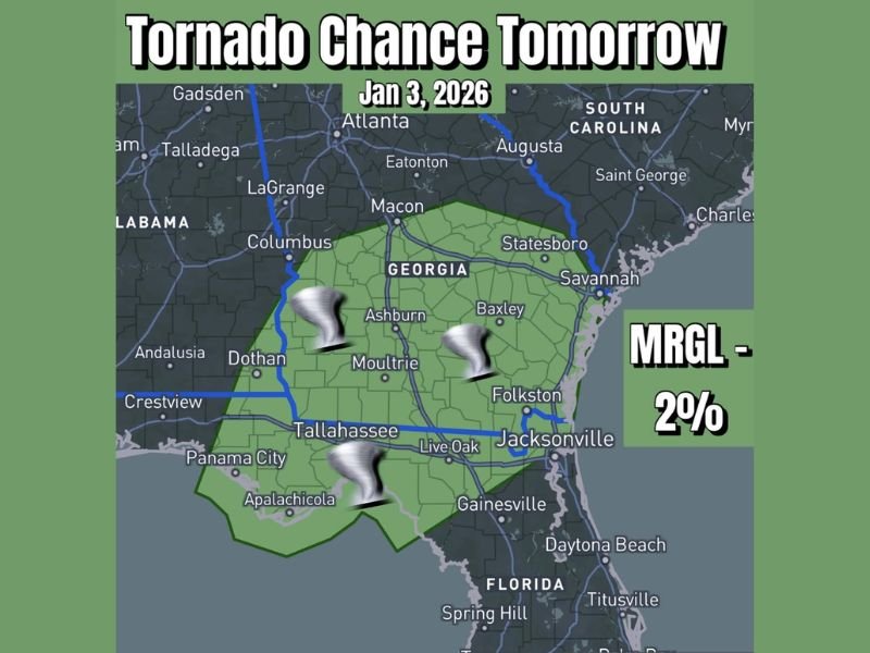
The provided outlook map highlights a Marginal Risk (2%) zone extending across southern Georgia and into portions of northern Florida, including areas near Tallahassee, Live Oak, Valdosta, and surrounding communities. A marginal risk represents the lowest level of tornado probability used in forecasting, but it still indicates that one or two tornadoes cannot be ruled out, particularly with stronger storm cells that briefly rotate.
Storms Expected to Form Ahead of Advancing Cold Front
The tornado potential is tied to storms forming ahead of a cold front moving across the Southeast. As the front approaches, increasing wind shear and low-level instability may allow a few storms to briefly intensify. While widespread severe weather is not expected, forecasters note that even marginal setups can produce short-lived tornadoes, especially in the Deep South where storms can develop quickly.
Any Tornadoes Likely to Be Brief and Isolated
Meteorologists stress that the overall environment does not support a widespread tornado outbreak. Any tornadoes that do form are expected to be weak, short-lived, and localized, often embedded within heavier rain showers or thunderstorms. Damaging winds or hail are not expected to be major concerns with this setup, making tornado potential the primary issue to monitor.
Residents Encouraged to Stay Weather-Aware Saturday
Emergency officials advise residents in southern Georgia and northern Florida to remain alert, especially during periods of heavier rainfall or thunderstorms. Having weather alerts enabled on mobile devices can provide critical warning if conditions change quickly. Even low-probability events deserve attention, particularly when storms occur during times when people may be traveling or away from shelter.
What to Expect Moving Forward
As the cold front passes, storm activity is expected to diminish, bringing quieter conditions behind the system. Forecasters will continue monitoring for any changes, but at this time the threat remains limited in scope. If you live in southern Georgia or northern Florida and experience severe weather Saturday, share your observations and stay informed with continued coverage from SaludaStandard-Sentinel.com.