Freezing Rain and Sleet Threaten Southern Plains Commute: Oklahoma and North Texas Drivers Warned of Slick Roads Monday Morning
OKLAHOMA CITY, OKLAHOMA — Drivers across the Southern Plains should brace for a hazardous Monday morning commute, as a mix of freezing rain, sleet, and light snow moves through portions of Oklahoma and North Texas. Forecasters are urging travelers to allow extra time and use caution, as freezing precipitation could lead to slippery roads and travel disruptions.
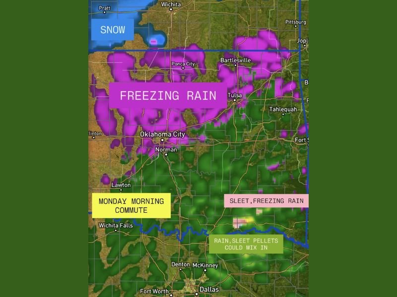
Radar projections show freezing rain developing overnight across central and northern Oklahoma, extending east toward Tulsa and south into Lawton, while north Texas — including areas near Wichita Falls and Denton — could see rain mixed with sleet pellets early in the morning.
Freezing Rain Expands Overnight
Meteorologists say the system is being fueled by a shallow layer of subfreezing air at the surface, overlain by a warm layer of moisture aloft — a setup ideal for freezing rain and sleet formation.
According to updated weather models, the heaviest freezing rain is likely along a corridor stretching from Oklahoma City to Tulsa, where road surfaces and elevated bridges could quickly become slick.
“This isn’t a major winter storm, but even light ice accumulation can make morning travel treacherous,” meteorologists cautioned late Sunday night.
Oklahoma Faces Slick Morning Commute
In Oklahoma City, temperatures are expected to hover near the freezing mark through sunrise, increasing the risk of icy spots on untreated roads. Residents in Norman, Stillwater, and Bartlesville could also see patchy glazing, particularly on overpasses and side streets.
The National Weather Service is advising commuters to reduce speed, increase following distances, and check road conditions before heading out Monday morning.
“Drivers should be prepared for slick spots and give themselves plenty of extra time,” one NWS meteorologist said. “Even a light glaze can lead to accidents during the morning rush.”
North Texas May See Sleet and Light Rain Mix
Farther south, North Texas communities — including Wichita Falls, Denton, and McKinney — could experience light rain mixed with sleet pellets early Monday before temperatures slowly climb above freezing later in the morning.
While significant icing is not expected in the Dallas–Fort Worth metro area, isolated slick bridges remain possible near the Red River and western counties where surface temperatures will be colder.
Impact and Safety Outlook
- Freezing rain and sleet: Most likely north of the Red River, especially central and northern Oklahoma.
- Snow: Possible in northwestern parts of Oklahoma near the Kansas border.
- Rain/sleet mix: Expected in southern Oklahoma and north Texas.
Forecasters emphasize that the primary hazard will be slick, icy roads — especially during the early-morning commute. Elevated surfaces such as bridges, ramps, and untreated secondary roads could ice up even with minor precipitation.
Conditions Improve by Afternoon
By late morning Monday, temperatures are forecast to climb just above freezing across much of the region, allowing the wintry mix to transition to light rain or drizzle. Conditions should improve steadily through midday.
However, meteorologists warn that another cold front later in the week could bring additional rounds of winter precipitation to the Southern Plains if temperatures drop again.
Residents are urged to stay alert to changing conditions and monitor official updates from the National Weather Service offices in Norman and Fort Worth.
For ongoing winter weather alerts, traffic updates, and safety resources, visit SaludaStandard-Sentinel.com — your trusted source for breaking weather coverage and community updates.