Forecast Models Signal Potentially Historic Arctic Blast for Texas, Oklahoma, Arkansas, Missouri, Illinois, and the Midwest Next Weekend
CENTRAL UNITED STATES — Long-range weather models are signaling a very intense Arctic blast likely to sweep across Texas, Oklahoma, Arkansas, Missouri, Illinois, and much of the Midwest next weekend. If the current projections hold, this could become the coldest air mass the region has experienced since February, marking a significant shift in early-winter conditions.
Models Show Deep and Widespread Temperature Anomalies
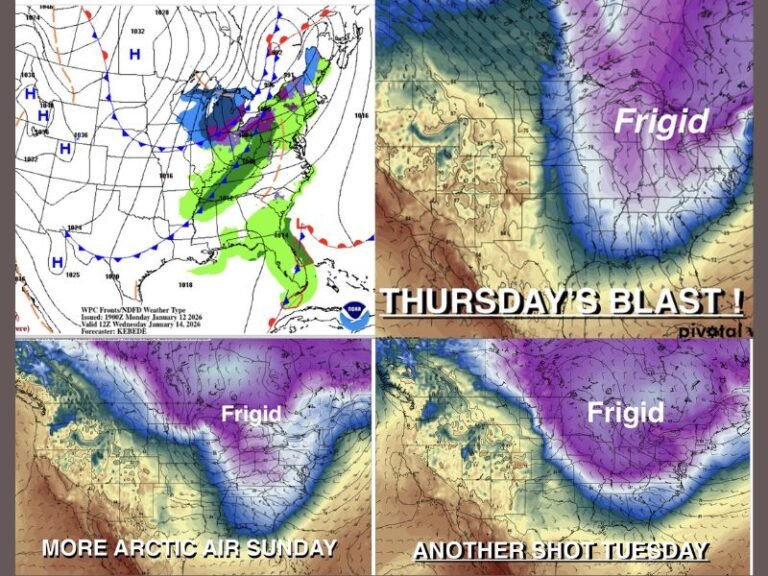
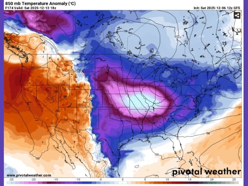
Forecast output from the GFS model highlights a massive surge of Arctic-origin air plunging deep into the central United States. Temperature anomaly maps show values running 10 to 25 degrees below typical mid-December norms, with the core of the cold centered over Kansas, Missouri, Illinois, and Nebraska.
The projected air mass at the 850 mb level—often used to gauge the depth of winter outbreaks—shows a striking region of purple and light-blue shading, a visual indication of very cold upper-level support. This pattern suggests that surface temperatures may fall sharply once the Arctic front moves through late next week.
Meteorologists caution that long-range forecasts carry uncertainty, but the persistence of the cold signal across multiple model runs increases confidence in a significant temperature drop across the central U.S.
Possible Coldest Conditions Since Last Winter
If the model trends continue, many locations across Texas, Oklahoma, Arkansas, Missouri, Illinois, and surrounding states could experience their lowest temperatures since February. Early projections hint at widespread lows in the teens and 20s, with single-digit temperatures possible in portions of the Midwest and Upper Mississippi Valley.
Wind chills could drop even lower, particularly in exposed and rural areas. While exact values are not yet clear, the evolving pattern strongly favors dangerous cold, especially for communities unprepared for an early-season Arctic intrusion.
Forecasters emphasize that the upcoming surge may unfold rapidly, producing a quick but intense period of frigid weather before moderating conditions return.
Residents Encouraged to Monitor Updates as Pattern Evolves
Forecasters advise residents across affected states to watch for daily updates as next weekend approaches. Even though uncertainty remains regarding the exact strength and timing of the Arctic blast, the potential impacts—ranging from hazardously low temperatures to dangerous wind chills—warrant early preparation.
If temperatures fall as projected, residents should plan to protect exposed pipes, ensure proper heating, and safeguard pets and livestock against the expected cold.
Have you already noticed early winter shifts across your area? Share your observations and stay connected with continuing coverage at SaludaStandard-Sentinel.com.