Forecast Models Show Significant Warm-Up Across Texas Next Week Before a Stronger Arctic Cold Blast Arrives the Following Weekend
TEXAS — After a cold start to December, forecast models show a major temperature rebound across Texas next week, with highs climbing into the 60s and 70s from Tuesday through Friday. A strengthening ridge from the West will bring sunny, dry conditions, providing Texans with a brief but noticeable break from early-winter chill. However, meteorologists warn that this warm-up may be short-lived, as confidence increases in a stronger Arctic cold blast arriving the following weekend.
Warm Temperatures Return as Upper-Level Ridge Builds
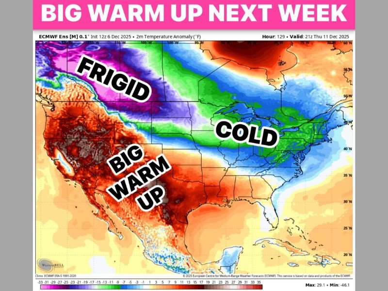
The ECMWF ensemble model highlights a large region of above-normal temperatures building across the southwestern United States, stretching into Texas. The warm anomaly is expected to peak midweek, allowing much of the state—including Houston, Austin, San Antonio, Dallas, and West Texas communities—to enjoy mild afternoons and quiet weather.
Sunshine will dominate, and no rainfall is projected during this warm spell. Meteorologists note that Texas often experiences these early December pattern flips, with cold fronts giving way to warm ridging before winter reasserts itself later in the month.
This warm stretch will likely feel dramatic after the colder-than-average first week of December, and residents are encouraged to enjoy it while it lasts.
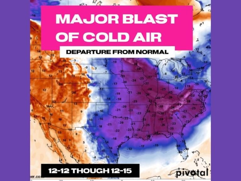
Models Increasingly Support a Strong Arctic Surge the Following Weekend
Behind this temporary warm-up, long-range data continues to signal a more intense surge of Arctic air targeting the central United States and Texas by next weekend. Some model runs show the possibility of the coldest air of the season moving southward, potentially dropping temperatures sharply within a 24-hour window.
The model map shows a striking contrast: frigid anomalies across the northern Plains, a broad warm sector across the Southwest including Texas, and a colder region already settling into the Midwest and Great Lakes. This type of jet stream alignment often precedes major pattern swings, where warm weather quickly gives way to strong Arctic fronts.
While forecast confidence is still developing, meteorologists agree that Texans should prepare for a rapid shift back to winter conditions, especially in the second half of next weekend.
Texans Encouraged to Take Advantage of the Thaw
The upcoming warm stretch is an ideal window for outdoor plans, home maintenance, and holiday preparations before the next major cold push arrives. Residents are encouraged to monitor daily forecasts, as the intensity and timing of the Arctic front will become clearer in the days ahead.
Have you noticed the early signs of next week’s warm-up across your area? Share your updates and stay informed with continued weather coverage at SaludaStandard-Sentinel.com.