Florida Warmth Could Roar Back Feb. 10, 2026, With Highs Near 80–81 After Weeks of Chilly Weather
FLORIDA — After what many residents describe as a colder-than-usual stretch, a new temperature outlook shows Florida could see a strong warm-up next week, with potential highs ranging from the low 70s in the Panhandle to around 80–81°F in South Florida on Tuesday, February 10, 2026.
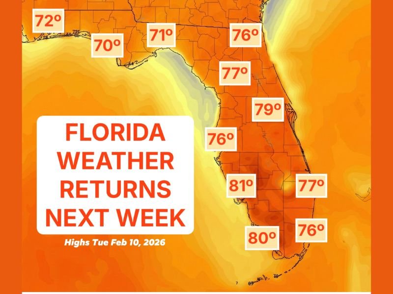
What the Forecast Map Suggests for Feb. 10
The data shows a classic “Florida weather returns” setup, with much of the state shaded in deep warm tones. The highest readings are focused in the southern half of the peninsula, while the northern tier stays milder but still comfortably warm for early February.
Across the state, the projected afternoon highs generally land in a 70–81°F range, signaling a major rebound compared to the cool pattern many Floridians have dealt with recently.
City-by-Region Temperature Targets Shown on the Map
The map places specific temperature markers across Florida, offering a snapshot of how the warmth may vary by region:
In the Panhandle, highs are shown near 70°F, with a 72°F marker closer to the far western edge. Across parts of North Florida, one marker shows 71°F, while the northeast portion of the state is tagged at 76°F.
Moving into the peninsula, the warmer air looks more established. Central Florida shows upper 70s, including a 77°F marker and a 79°F marker along the east side. On the Gulf side, a 76°F marker suggests a warm but not extreme afternoon.
Farther south, the warmest numbers appear. A Southwest Florida marker reaches 81°F, and near the southern end of the peninsula another marker shows 80°F. Along the southeast coast, markers show mid to upper 70s, including 76°F and 77°F.
Why This Warm-Up Would Feel So Noticeable
Even though Florida doesn’t experience “deep winter” the way much of the country does, a couple weeks of repeated cool fronts can reset expectations fast—especially when mornings start chilly and afternoons stay muted.
That’s why highs back in the upper 70s and low 80s can feel like a full return to peak-season conditions: more outdoor comfort, warmer coastal breezes, and a noticeably different feel compared to the recent cool spells.
What Could Change Before Next Week Arrives
Because these are potential highs shown several days out, exact numbers could still shift depending on the position of the next weather system. If a front arrives later than expected, the warm air can hold longer and expand north. If a front pushes through earlier, some areas—especially North Florida—could end up a few degrees cooler than currently projected.
Still, the signal is clear: the overall pattern next week supports a broad warm-up, with the strongest heat centered over the peninsula.
If you’re in Florida, are you ready for the return of 80-degree afternoons—or did you actually enjoy the cooler stretch? Share what you’re seeing where you live and keep following updates at SaludaStandard-Sentinel.com.