Florida Temperatures Set to Plunge Into the 30s Tuesday, Breaking Records Across the State
TALLAHASSEE, Fla. — An unusually sharp cold front is expected to bring record-breaking temperatures to Florida early next week, with forecasters warning that parts of the state could dip into the 30s by Tuesday morning.
According to meteorologists at Spaghetti Models, the latest forecast models show the coldest air of the season sweeping deep into Florida by November 11, marking a dramatic drop from recent above-average temperatures.
30s Reaching Deep Into Central and South Florida
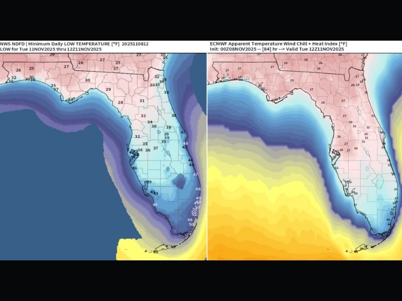
The latest National Weather Service (NWS) data shows widespread lows in the mid to upper 30s stretching from the Panhandle through central Florida, while some areas near Orlando and Tampa Bay could briefly touch the upper 30s to low 40s.
Even South Florida, including parts of Fort Myers, West Palm Beach, and Miami, may see temperatures in the 40s, with feels-like readings approaching the upper 30s due to wind chill, according to the European Model (ECMWF) projections.
“This front is strong enough to push deep into the peninsula, breaking several temperature records in the process,” forecasters said, noting that multiple daily lows from previous years could be surpassed.
Wind Chills and Record Potential
The European model’s wind chill map shows apparent temperatures running 10–15 degrees colder than the actual readings, meaning that many Floridians will wake up to a morning that feels more like late January than early November.
Some interior counties could even experience freezing or near-freezing conditions, particularly across northern and north-central Florida, raising concern for sensitive crops and outdoor vegetation.
“This is shaping up to be one of the most widespread early-season cold snaps in recent memory,” meteorologists added. “We could easily see a bunch of daily record lows fall on Tuesday.”
Residents Urged to Prepare for the Chill
Residents across the state are being urged to take precautions to protect plants, pets, and pipes, especially in rural or inland areas. People heading out early Tuesday should dress in layers and be prepared for the sharp temperature drop before sunrise.
Daytime highs are expected to rebound slightly into the 50s and 60s by afternoon, but another cold night is expected Tuesday into Wednesday before milder air returns later in the week.
Stay updated with the latest Florida weather developments and temperature alerts at SaludaStandard-Sentinel.com.