Florida Swings From 90s to 20s and 30s: Arctic Blast to Send Actual Temperatures Plunging Statewide by Tuesday Morning
FLORIDA — After a weekend of summer-like heat with highs soaring into the 80s and even 90s, Florida is preparing for a dramatic temperature plunge that will send much of the state back to winter levels by Monday night and Tuesday morning. And forecasters emphasize: these are actual temperatures — not wind chills.
From Beach Weather to Winter Weather
The rapid shift follows a warm, humid stretch that made it feel more like late spring or early summer across much of the Sunshine State.
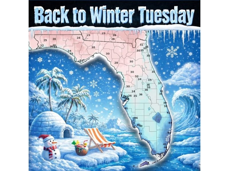
But behind an approaching cold front, a surge of much colder air will spill southward, pushing temperatures down sharply across the peninsula. By Tuesday morning, the latest National Weather Service projections show widespread 20s and 30s across North and Central Florida.
Where Temperatures Will Drop the Most
Forecast lows by early Tuesday include:
- Upper 20s to low 30s across the Florida Panhandle
- Around 28–32 degrees across North Florida
- Low to mid-30s stretching through Central Florida
- Mid to upper 30s in the Orlando area
- Low 40s across South Florida
- Mid to upper 40s near Miami and the Keys
This marks a significant swing from highs in the upper 80s and 90s just days prior.
Not Wind Chills — Actual Temperatures
Forecasters are making it clear: these projected readings are actual air temperatures. That means frost potential in parts of North and Central Florida, especially in inland and rural areas where temperatures can dip slightly lower than urban centers. Residents who may have already packed away winter clothing will likely need to break out jackets and layers again for early morning hours.
Impact on Plants, Pets, and Outdoor Plans
The cold snap could impact:
- Sensitive plants and early spring gardens
- Outdoor pets
- Overnight campers
- Early morning commuters
Residents are encouraged to take precautions, especially in areas forecast to dip into the upper 20s and lower 30s.
A Classic Florida Weather Whiplash
The dramatic swing from 90-degree warmth to freezing or near-freezing temperatures highlights the volatility of late-winter and early-spring weather patterns.
Strong cold fronts moving deep into the Southeast can create sharp contrasts in just 24 to 48 hours — and this upcoming system appears to be one of the more significant cool-downs of the season.
What Comes Next?
Temperatures are expected to gradually moderate later in the week, but the early Tuesday morning period will likely represent the coldest stretch of this pattern.
Residents are urged to monitor local forecasts for updated low temperature projections and any frost advisories that may be issued. Stay with SaludaStandard-Sentinel.com for continued updates as Florida transitions from beach weather back to winter conditions.