Florida Rainfall Divide This Week Puts Miami, Daytona Beach Under Heavy Multi-Day Downpours While Tampa Stays on Drier Side
FLORIDA — A sharp rainfall divide is expected across the state this week, with eastern regions bracing for significant multi-day downpours while parts of the Gulf Coast, including Tampa, remain on the drier side of the system.
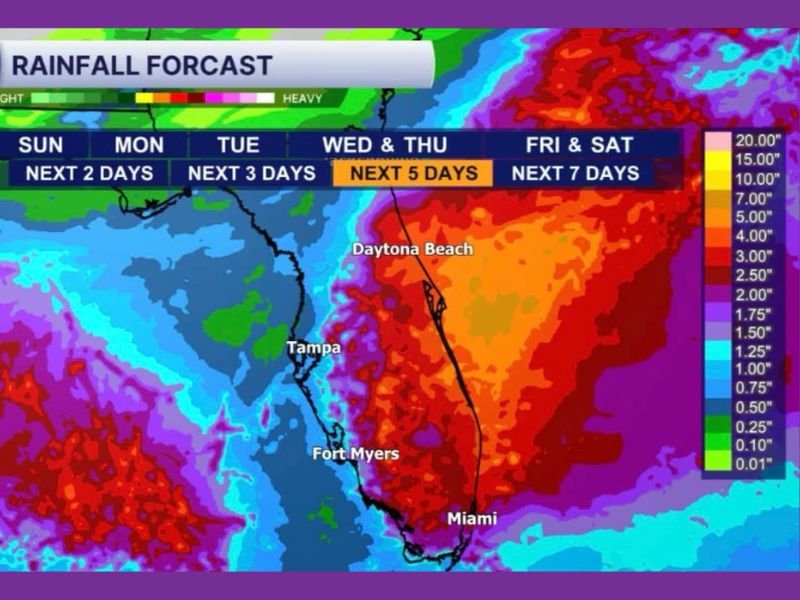
Forecast data shows a pronounced contrast setting up across Florida, where moisture-rich weather patterns are focusing heaviest rainfall along the Atlantic side. Cities like Miami and Daytona Beach are positioned directly in the zone expected to receive the most intense precipitation totals over the next several days.
Eastern Florida Faces Multi-Day Heavy Rain Threat
The forecast highlights a concentrated corridor of heavy rain stretching from South Florida through the eastern peninsula. Miami appears to be among the hardest-hit areas, with rainfall totals potentially reaching several inches over the next five to seven days.
Daytona Beach is also in a high-impact zone, where persistent rain bands could lead to localized flooding concerns, especially in low-lying or poorly drained areas. The extended duration of rainfall increases the risk of water accumulation rather than quick-moving storms.
This setup suggests a steady feed of moisture from surrounding waters, allowing rain to repeatedly develop and move over the same regions. As a result, rainfall totals could build quickly, even if individual storms are not particularly severe.
Tampa and Gulf Coast Remain on the Drier Side of the System
In contrast, Tampa and much of Florida’s Gulf Coast fall on the “wrong side” of the heaviest rain shield. Forecast projections indicate significantly lighter totals in these areas, with some locations seeing only scattered showers rather than sustained rainfall.
While residents in western Florida will still experience occasional rain, the overall pattern suggests less frequent and less intense precipitation compared to the eastern half of the state. This uneven distribution highlights how narrowly focused the heaviest rainfall band is expected to be.
The difference between coasts may become especially noticeable as the week progresses, with eastern areas continuing to deal with wet conditions while western regions see breaks in cloud cover and limited rainfall accumulation.
Extended Rainfall Pattern Raises Flooding Concerns in Eastern Cities
The extended nature of this weather pattern is one of the most important factors. Rather than a single storm event, the forecast spans multiple days, allowing rainfall to accumulate gradually.
For areas like Miami and Daytona Beach, repeated rounds of rain could saturate the ground, increasing the chances of minor flooding in urban areas, roadways, and drainage systems. Even moderate rain over several consecutive days can create impacts similar to a single heavy storm.
Meanwhile, areas like Fort Myers sit closer to the dividing line, meaning rainfall totals could vary significantly depending on slight shifts in the system’s track.
What Residents Across Florida Should Expect This Week
Residents on Florida’s east coast should prepare for a prolonged period of wet weather, including occasional heavier bursts of rain. Travel disruptions, reduced visibility, and localized flooding may become concerns as the week unfolds.
On the Gulf Coast, conditions will be more mixed, with occasional rain but also longer dry intervals. However, slight shifts in the weather pattern could still bring changes, so conditions should be monitored closely.
Overall, the key takeaway from this forecast is the sharp contrast across the state, where some areas may see substantial rainfall totals while others remain relatively unaffected.
As this weather pattern develops, have you started seeing rain differences in your area? Share your local conditions and experiences with us at SaludaStandard-Sentinel.com and join the conversation.