Florida Braces for Tropical-Storm-Force Winds as Powerful Cold Front Triggers 50 MPH Gusts and Sharp Temperature Drop
FLORIDA — A powerful cold front is set to sweep across Florida on Sunday, bringing unusually strong winds that could rival low-end tropical storm conditions across much of the peninsula, according to the latest forecast data. Meteorologists warn that wind gusts could approach or exceed 50 miles per hour in some locations, creating hazardous conditions even in the absence of heavy rain or thunderstorms.
Why Winds Could Feel Like a Tropical Storm
While this system is not tropical in nature, the pressure gradient associated with the advancing cold front is exceptionally strong, allowing winds to accelerate rapidly across the state. As the front pushes southward, tight pressure differences between the departing warm air mass and incoming cold air will act like a wind tunnel, especially across coastal and exposed inland areas.
Forecasters note that strong cold fronts are often capable of producing some of the strongest non-tropical wind events in Florida, and this setup is no exception.
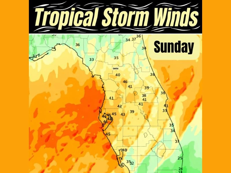
Where the Strongest Gusts Are Expected
The Florida Peninsula appears to be the primary target for the most intense winds, with coastal regions along the Gulf Coast and Atlantic Coast particularly vulnerable. Inland areas are not immune either, as wind speeds could remain strong enough to down tree limbs, blow around unsecured objects, and cause isolated power outages.
Some locations may experience sustained winds in the 30–40 mph range, with higher gusts peaking near 50 mph, especially during the height of frontal passage.
Timing: When Conditions Will Worsen
Winds are expected to increase rapidly Sunday morning, becoming strongest through the late morning and afternoon hours as the cold front moves through. Conditions may remain blustery into the evening before gradually easing overnight.
By early Monday morning, winds will begin to relax, but they will usher in a much colder air mass, marking a noticeable shift in temperatures across the state.
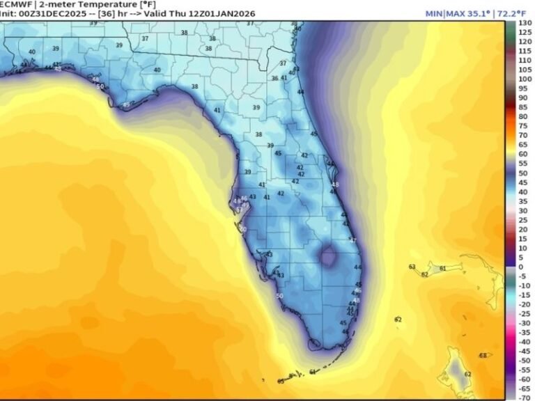
Colder Air Arrives Behind the Front
Once the front clears Florida, frigid air for the region will spill southward, bringing the coldest conditions many areas have felt in weeks. Morning lows on Monday are expected to dip sharply, with wind chills making the cold feel even more pronounced, especially during the early hours.
This rapid transition from windy warmth to cold, blustery conditions is classic of strong winter cold fronts, and it can catch residents off guard.
Potential Impacts Residents Should Prepare For
Although widespread structural damage is not expected, the combination of strong winds and falling temperatures raises several concerns. Loose outdoor items may become airborne, high-profile vehicles could face difficult driving conditions, and boaters should avoid open waters during peak wind hours.
Residents are advised to secure outdoor furniture, trash bins, and decorations, and to prepare for brief power disruptions, particularly in wind-prone areas.
Why This Event Stands Out
Meteorologists emphasize that wind events of this magnitude are more typical of tropical systems, making this cold-front-driven setup especially noteworthy. While Florida is no stranger to gusty weather, Sunday’s winds may feel unusually intense for a winter system, reinforcing just how dynamic this weather pattern has become.
Have you experienced strong winter winds like this before in your area? Share your observations and stay informed with continued weather updates from SaludaStandard-Sentinel.com.