Florida Braces for Rare Arctic Outbreak as Dangerous Wind Chills Drop Into Single Digits Across the Panhandle and North Florida
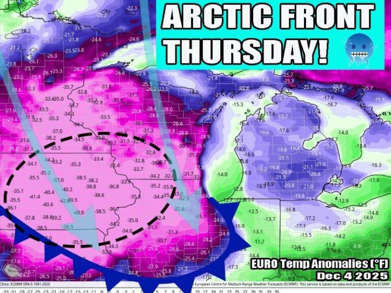
FLORIDA — A powerful surge of Arctic air is set to sweep across Florida this weekend, bringing dangerously cold wind chills to a state unaccustomed to winter extremes. Forecast data shows single-digit wind chills across the Florida Panhandle and North Florida, with teens reaching into Central Florida and 20s even as far south as South Florida, marking one of the most widespread cold events of the season.
Arctic Air Pushes Deep Into the Sunshine State
This cold outbreak is being driven by a strong Arctic air mass plunging southward, reinforced by persistent north winds that will significantly lower feels-like temperatures statewide. Unlike a typical cool snap, this system carries enough momentum to push brutal cold well beyond North Florida, impacting regions that rarely experience such conditions.
The combination of cold air and wind will make temperatures feel far colder than actual readings, increasing the risk for cold-related hazards across the state.
Wind Chill Forecast by Region
Forecast wind chill values highlight the unusual severity of this event:
- Florida Panhandle and North Florida: Single-digit wind chills
- Central Florida (including Orlando and Tampa): Teens
- South Florida (including Fort Myers and Miami): Low to mid-20s
Even coastal and urban areas typically protected from extreme cold are expected to feel the impact, particularly during the overnight and early morning hours.
Why Wind Makes This Cold Especially Dangerous
Wind chills are expected to be the primary concern during this event. Sustained winds will strip away body heat rapidly, making outdoor exposure risky in a short period of time. Conditions like this can lead to hypothermia faster than many Floridians anticipate, especially for those unprepared or dressed lightly.
The cold will feel harsh and unforgiving, particularly before sunrise when temperatures and wind chills bottom out.
Impacts on Homes, Pets, and Infrastructure
This level of cold increases the risk of frozen pipes, especially in homes not designed for freezing temperatures. Outdoor plumbing, irrigation systems, and exposed pipes are especially vulnerable.
Pets should be brought indoors, and sensitive plants may suffer damage if left unprotected. Residents relying on space heaters should use them with caution to avoid fire hazards.
Timing and Duration of the Cold Snap
The coldest conditions are expected late Saturday night into Sunday morning, with gradual improvement later in the day. However, morning wind chills will remain bitter, making early outdoor activity uncomfortable and potentially unsafe.
Some areas may see multiple hours of sub-freezing wind chills before conditions slowly moderate.
What Residents Should Do Now
Residents are urged to take this cold seriously, even if actual temperatures do not appear extreme. Dressing in layers, limiting outdoor exposure, and checking on vulnerable neighbors can make a significant difference during this event.
This is not a typical Florida winter morning — it is a statewide cold event with real risks.
Stay informed, stay prepared, and continue following SaludaStandard-Sentinel.com for ongoing weather updates and impact-focused coverage as this Arctic surge unfolds.