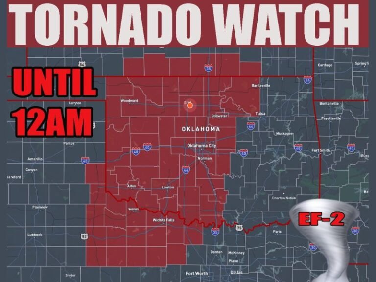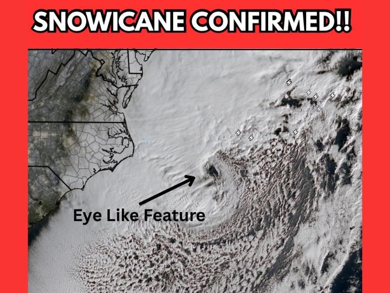
Eye-Like “Snowicane” Structure Forms Offshore as Powerful Bomb Cyclone Pulls Away From North Carolina Outer Banks
NORTH CAROLINA — A powerful winter storm system intensifying off the Atlantic coast has developed an eye-like feature as it pulls away from the North Carolina Outer Banks, prompting meteorologists to describe the system as a rare and dramatic “snowicane” — a hybrid structure associated with strong bomb cyclones rather than tropical storms.
Satellite imagery confirms the presence of a distinct circular clearing within the storm’s cloud shield, a visual hallmark of extreme low-pressure systems undergoing rapid strengthening over open water.
What the “Snowicane” Structure Indicates
The eye-like appearance does not mean the storm is a hurricane, but it does signal exceptional organization and strength for a cold-season cyclone. These features occur when a storm rapidly deepens, tightening its pressure gradient and intensifying wind fields around the center.
In this case, the bomb cyclone has developed exactly as forecast models suggested, validating earlier projections of explosive strengthening offshore of the Carolinas.
Meteorologists often refer to these systems informally as “snowicanes” because they visually resemble tropical cyclones while producing winter weather impacts rather than warm-core rainfall.
Winds Reaching Category-2-Equivalent Strength Offshore
According to the forecast information accompanying the imagery, offshore wind gusts are now reaching Category 2 hurricane-equivalent strength, an extraordinary benchmark for a non-tropical storm.
These winds are occurring over open waters east of the Outer Banks as the system pulls farther into the Atlantic. While the strongest gusts remain offshore, the energy driving the storm highlights just how intense the pressure drop has become. Such winds can generate extremely rough seas, significant wave heights, and dangerous marine conditions, even without a named tropical system.
Why Bomb Cyclones Can Look Like Hurricanes
Bomb cyclones form when a storm’s central pressure drops rapidly — typically at least 24 millibars in 24 hours — driven by strong temperature contrasts and upper-level jet stream support.
As cold Arctic air collides with warmer ocean air, the storm feeds on that energy, tightening circulation and sometimes creating a visible eye-like center. Unlike hurricanes, however, these storms are cold-core systems fueled by atmospheric dynamics rather than ocean heat. The result can still be just as visually striking — and just as dangerous.
Impact Focus Remains Offshore, But Effects Are Far-Reaching
Although the storm’s core is now pulling away from the North Carolina coastline, its influence extends across a wide swath of the western Atlantic. Strong offshore winds can continue to impact shipping lanes, fishing operations, and coastal waters long after the center departs. For coastal communities, the storm serves as a reminder that winter systems can rival tropical storms in intensity, even if they lack official hurricane classification.
A Rare but Not Unprecedented Winter Phenomenon
Snowicanes are uncommon but not unheard of along the U.S. East Coast. When they do occur, they often become textbook examples of how powerful mid-latitude cyclones can become under the right conditions.
Meteorologists emphasize that while these storms may look like hurricanes on satellite imagery, their impacts, structure, and behavior remain firmly rooted in winter weather dynamics. For continued updates on major storm systems, extreme weather patterns, and coastal impacts across the Carolinas and beyond, follow ongoing coverage at SaludaStandard-Sentinel.com.