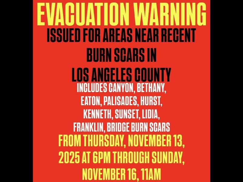
Evacuation Warnings Issued for Los Angeles County Burn Areas Ahead of Heavy Rain and Flood Threat
LOS ANGELES, CALIFORNIA — Officials have issued evacuation warnings for multiple areas across Los Angeles County ahead of an incoming storm system expected to bring heavy rainfall, potential flooding, and landslides. The warnings apply specifically to neighborhoods near recent wildfire burn scars, where unstable soil increases the risk of debris flows.
Evacuation Warning in Effect Through Sunday
According to meteorologist Chris Nunley, the evacuation warning will remain in effect from Thursday, November 13 at 6 p.m. through Sunday, November 16 at 11 a.m. Residents are being urged to prepare for possible mandatory evacuations if conditions worsen overnight.
The alert includes several areas with known burn scars: Canyon, Bethany, Eaton, Palisades, Hurst, Kenneth, Sunset, Lidia, Franklin, and Bridge burn zones. These locations are considered especially vulnerable due to steep terrain and loose soil left behind by past wildfires.
Risk of Flash Flooding and Landslides
The National Weather Service (NWS) warned that the combination of saturated ground and steep canyon slopes could lead to flash flooding, mudslides, and debris flows across hillside communities. Even moderate rainfall rates may be enough to trigger landslides in recently burned regions.
Officials are advising residents to avoid low-lying roads, drainage areas, and creek crossings, and to be ready to leave immediately if evacuation orders are issued.
“Burn areas can fail without warning,” said an NWS spokesperson. “If you live near one of these zones, don’t wait for an official order — move to safety if conditions begin to deteriorate.”
Emergency Services on High Alert
Los Angeles County emergency crews and public works departments have pre-deployed resources, including sandbags and road crews, to assist with potential flash flood impacts. Search and rescue teams remain on standby, and officials are coordinating with the California Office of Emergency Services to monitor rainfall intensity and ground movement.
Meteorologists expect the heaviest rainfall to occur Thursday night through early Friday, with scattered showers continuing through the weekend.
Residents Urged to Stay Prepared
County officials are reminding residents to:
- Keep emergency kits ready, including flashlights, water, and medications.
- Charge mobile devices in advance.
- Monitor official weather alerts and local evacuation notices.
- Avoid driving through flooded roads or areas prone to washouts.
Safety Reminder
Authorities emphasized that even short bursts of intense rain can quickly overwhelm hillside areas weakened by past fires. Floodwaters and debris flows can move rapidly, carrying rocks, mud, and vegetation downhill into populated neighborhoods.
Residents are encouraged to follow updates through Los Angeles County Fire Department, Ready L.A., and the National Weather Service Los Angeles on social media for real-time alerts.
Have you been affected by evacuation orders or flooding near your area? Share your story and safety tips with the community at SaludaStandard-Sentinel.com.