European Forecast Model Shows Heavy Rain Band Targeting North and Central Florida as Moisture Train Sets Up Through Monday
FLORIDA — The European weather model (ECMWF) is projecting a broad, intensifying band of rainfall stretching across North and Central Florida, with totals potentially exceeding 2 inches in some areas as a moisture-rich pattern settles over the state through Monday. The setup stands in contrast to lighter amounts expected across South Florida, where rainfall remains minimal.
Euro Model Highlights a Strong Moisture Stripe Across the Peninsula
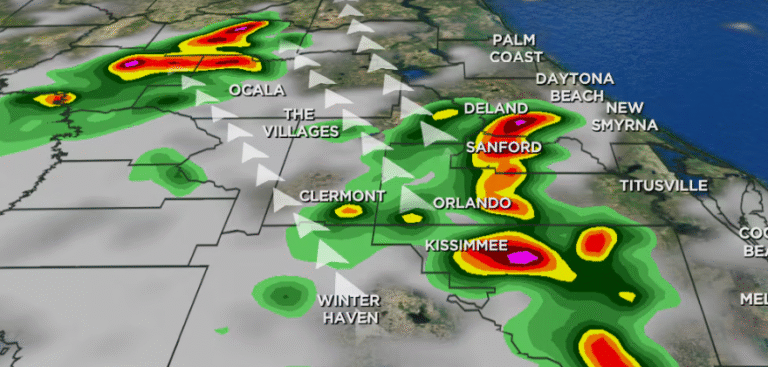
Forecasters note that the ECMWF has been consistent in showing a bright orange-to-red stripe extending across the northern half of the state, signaling significant precipitation potential from the Panhandle to portions of Central Florida. Rainfall projections between 1–3 inches appear common within this corridor, with locally higher amounts possible if the moisture plume strengthens.
The model imagery shows the highest totals clustered along the I-10 corridor and into counties north of Orlando, where the system may slow and deposit repeated rounds of rain. While not a severe-weather setup, the Euro suggests rainfall intense enough to cause ponding on roads and reduced visibility, especially during heavier pockets.
Different Impacts for North, Central, and South Florida
The upcoming rainfall event will likely produce very different experiences depending on region:
- North Florida is in line for the heaviest rainfall, with totals potentially rising above 2 inches in some locations. Forecast maps indicate a well-defined zone of higher accumulation spanning Tallahassee, Lake City, and Jacksonville.
- Central Florida may see moderate rainfall, though amounts appear less uniform. Areas north of the I-4 corridor show 1–2 inches, while southern portions may see far less as the core moisture stays to the north.
- South Florida continues to fall outside the main rain axis, with projections showing minimal accumulation, generally under 0.5 inches. The southern peninsula remains under drier influence as the moisture band positions itself farther north.
Meteorologists emphasize that North and Central Florida should monitor updates, as slight shifts in the moisture band could alter rainfall totals.
Forecasters Expect Soggy Conditions Through Monday
The ECMWF’s depiction of a steady moisture corridor supports widespread wet conditions through the start of the week. While not a severe event, forecasters warn of slick roads, localized drainage issues, and brief periods of heavier downpours as embedded waves move along the moisture axis.
The system’s placement is key — and according to the Euro, Florida’s peninsula is about to receive a sustained period of measurable rainfall, particularly for residents in the northern half of the state.
Have conditions already begun to change where you live? Share your observations and follow ongoing updates at SaludaStandard-Sentinel.com.