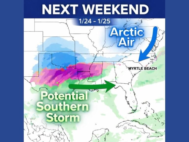
ECMWF Model Signals Possible Northeast Storm Pattern Shift Later in January, But Forecast Confidence Remains Low
NEW YORK — The latest 12z ECMWF guidance is beginning to hint at a potential storm signal roughly 11 days out, but forecasters stress that this is not a forecast and should be treated as an early pattern recognition rather than a specific event. At this range, the focus is not on exact outcomes, but on whether large-scale atmospheric signals are aligning with a broader trend discussed earlier in the winter.
The emerging signal reflects a possible gradual return toward classic Miller-type storm systems, a pattern that can support coastal or interior winter storms across the eastern United States. However, meteorologists emphasize that this single run alone is not enough to confirm that such a system will ultimately develop.
Why This ECMWF Signal Is Being Watched Carefully
Rather than chasing a single operational run, forecasters are watching to see whether ensemble guidance and additional operational data begin reinforcing the same idea over the coming days. At long range, consistency matters far more than intensity, and right now, the signal remains subtle.
The ECMWF run suggests a developing setup that could support precipitation across the Mid-Atlantic and Northeast, but confidence remains limited due to the extended timeframe. Any meaningful forecast will require multiple consecutive model runs showing similar structure and placement.
Subtle Pacific Changes Add Context to the Pattern
Beyond the Atlantic side of the pattern, forecasters are also noting subtle but meaningful changes developing across the Pacific. These upstream adjustments are important, as Pacific influences often play a critical role in shaping downstream storm tracks over North America.
The presence of these Pacific changes lends additional credibility to the broader idea of pattern evolution, even if the specific storm shown on this run never materializes. It suggests the atmosphere may be gradually shifting toward a configuration more favorable for organized systems later in the month.
No Guarantee of a Storm, But the Trend Remains Valid
Meteorologists are clear that this particular storm depiction may never verify. What remains significant is that the larger-scale setup continues to support the underlying trend, even if individual runs fluctuate. This distinction is critical for long-range forecasting, where pattern recognition matters more than precise details.
As January progresses, forecasters will be watching for reinforcement from ensemble data, which would increase confidence that the pattern change is real rather than noise.
What Residents Should Take Away Right Now
For residents across the Northeast, this information should be viewed as something to note, not something to act on. There is no immediate impact, no confirmed storm, and no reason for preparation at this time.
Still, the signal is notable because it aligns with earlier discussions of how winter patterns could evolve later in the season. If future data continues to support this trend, clearer guidance will follow in the days ahead. Readers are encouraged to continue monitoring updates as confidence either strengthens or fades with incoming data. Stay informed with ongoing weather coverage from SaludaStandard-Sentinel.com.