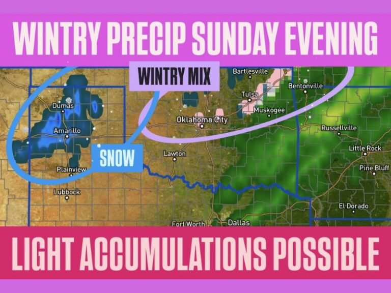
ECMWF Flags a Deep Southern Plains Storm Around Feb. 18, With Oklahoma and North Texas in the Crosshairs
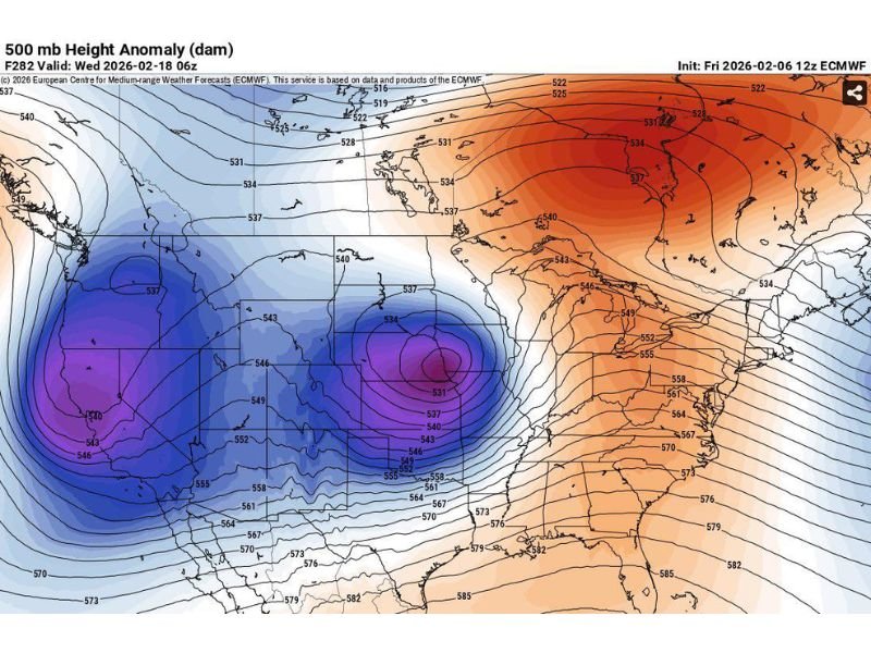
UNITED STATES — A new look from the European forecast model is raising eyebrows for the middle of February, showing a very deep upper-level storm carving into the Southern Plains around February 18. The tight swirl of energy on the mid-atmosphere map is centered near Oklahoma and North Texas, and when the pattern looks that intense several miles up, it often signals the potential for meaningful weather closer to the ground.
What the Model Is Showing Over Oklahoma and North Texas
The map depicts a compact, high-energy circulation aloft that stands out because of how “wrapped up” it appears. In plain terms: the atmosphere is organizing a strong system, and the Southern Plains sit right where these setups can become impactful—especially when Gulf moisture is available to feed it.
Why This Setup Can Produce Very Different Outcomes
Systems this strong don’t always translate into the same kind of local weather. One scenario is that the storm pulls Gulf moisture north, creating rounds of heavy rain and stronger thunderstorms somewhere in the Southern Plains region. Another scenario is a more classic late-winter twist: the system drags cold air in on the backside, producing a burst of winter weather before it exits.
At this range, the key takeaway isn’t the exact impact type yet—it’s the signal that the atmosphere may be loading the dice for something more active than a quiet February week.
The Bigger Story: A Highly Amplified National Pattern
What makes this worth watching is the broader pattern across the country. The model depiction shows a big ridge over the East and a deep trough in the middle of the U.S. That “ridge-and-trough” contrast is a high-energy configuration that often produces impactful weather somewhere along the boundary between warm, moist air and colder air.
What To Watch As Mid-February Gets Closer
This is still more than a week out, so think of it as pattern recognition, not specifics. Over the next several days, forecast confidence usually improves on three things:
- Track: where the core of the system sets up
- Moisture return: how much Gulf air pushes north
- Temperature profile: whether this trends stormy, wintry, or both
If you live anywhere from Texas into Oklahoma and surrounding states—or you have travel plans around mid-February—this is a period you’ll want circled for updates.
If you want more weather breakdowns like this as the pattern sharpens, follow along and share what you’re seeing where you live at SaludaStandard-Sentinel.com.