Eastern North Carolina Sees Overnight Rain and Thunder as Cold Front Moves Through Greenville, Goldsboro, Jacksonville and Wilmington
NORTH CAROLINA — A cold front pushing east across the state late Sunday night is bringing rounds of rain and occasional thunder to eastern North Carolina, with showers expected to continue through the overnight hours.
Cities including Greenville, Goldsboro, Jacksonville, Wilmington, and surrounding communities are seeing periods of steady rainfall, offering much-needed moisture along with cooler, calmer nighttime conditions.
Cold Front Triggers Rain Bands Across Eastern North Carolina
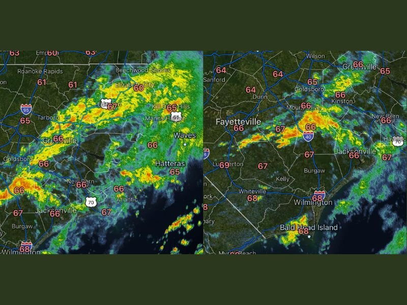
Radar imagery shows a line of rain stretching across eastern portions of the state, with pockets of heavier showers moving through areas like Greenville and Elizabeth City.
As the cold front advances, it is helping to generate additional rainfall and isolated rumbles of thunder, particularly in areas along and east of Interstate 95. The system is not expected to produce severe weather, but it is delivering steady rain across a wide portion of the region.
Heavier Showers Moving Through Goldsboro, Kinston and Jacksonville
Some of the more concentrated rainfall is impacting areas around Goldsboro, Kinston, and Jacksonville, where radar indicates moderate to occasionally heavier showers.
These rain bands are moving steadily eastward, meaning locations may experience bursts of rain followed by lighter conditions as the system progresses. Temperatures across the region are remaining mild, generally in the mid to upper 60s, supporting a comfortable but damp overnight environment.
Wilmington and Coastal Areas See Intermittent Rain
Closer to the coast, including Wilmington and Bald Head Island, rain is arriving in waves rather than continuous downpours.
This pattern is typical with a passing front, where showers move in and out over several hours rather than remaining constant. Coastal areas may continue to see scattered showers into the early morning hours before conditions begin to improve.
Thunder Possible but Severe Weather Not Expected
While most of the activity is focused on rain, there have been occasional reports of thunder embedded within the system. These isolated rumbles are a result of instability along the frontal boundary, though the overall setup does not favor severe storms. Residents may hear brief thunder overnight, but impacts are expected to remain minimal.
Rain Provides Relief and Cooler Nighttime Conditions
The rainfall associated with this system is providing beneficial moisture across eastern North Carolina, especially in areas that have needed rain. In addition to precipitation, the cold front is helping to bring slightly cooler air into the region, contributing to what many may consider ideal sleeping conditions.
As the front continues offshore, conditions are expected to gradually dry out heading into the next day. As the rain moves through your area tonight, are you hearing thunder or just steady showers? Share your local conditions with us at SaludaStandard-Sentinel.com.