Eastern Kentucky Snowfall Forecast Shows Spotty Wednesday–Thursday Accumulations That Could Still Trigger School Delays and Travel Issues
KENTUCKY — A light but uneven snowfall is expected across eastern Kentucky from Wednesday into Thursday, and while totals will be modest, forecasters warn the streaky nature of the snow could still lead to travel slowdowns and possible school delays or closings in some communities.
Timing: Wednesday Into Thursday
Forecast maps show snow developing during the day Wednesday and lingering into early Thursday, particularly across eastern and southeastern Kentucky. The system is not expected to be a major winter storm, but its timing could impact the Wednesday night and Thursday morning commute in localized areas.
How Much Snow Is Expected
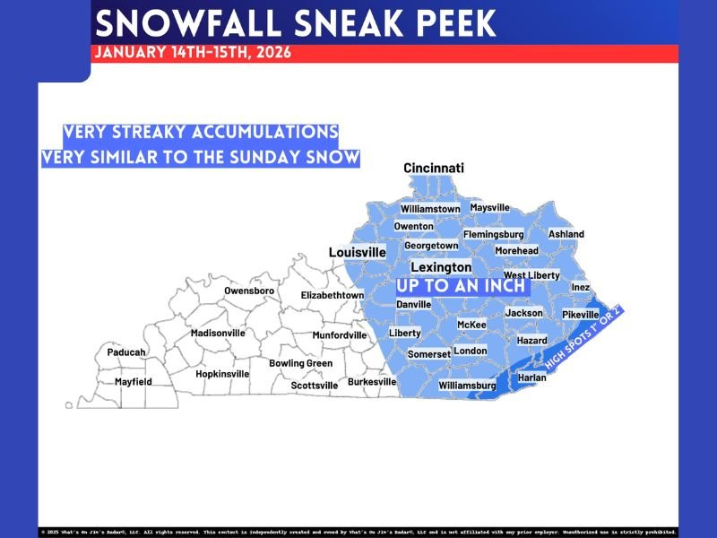
Most locations in eastern Kentucky are forecast to see up to around one inch of snow, with isolated higher totals possible in a few favored spots. Forecasters stress that this event will be highly uneven, meaning snowfall amounts could vary significantly over short distances. In some counties, one part of the area could see close to an inch, while nearby communities may see little to no accumulation at all.
Why Accumulations Will Be So Uneven
Meteorologists describe this setup as very streaky, similar to a recent Sunday snow event. Narrow bands of snow will determine who sees accumulation and who does not, making precise forecasts difficult even just hours before snow begins. This type of pattern often leads to surprise slick spots, especially on untreated roads and bridges.
Areas Most Likely to See Snow
The highest chances for measurable snow extend from Lexington eastward through communities such as Morehead, Hazard, Pikeville, Harlan, and surrounding areas. Western Kentucky is expected to see little to no impact from this system. Even within the snow zone, totals will vary widely depending on where bands set up.
Potential Impacts Despite Light Totals
Although snowfall amounts are expected to be relatively small, even light snow can cause issues, particularly during colder nighttime hours. Reduced visibility, slick roads, and patchy accumulations could lead to minor travel disruptions and localized school schedule changes. Residents are encouraged to monitor local updates, especially if traveling early Thursday.
Bottom Line
This will not be a widespread or heavy snow event, but its inconsistent nature makes it one to watch closely. Forecasters caution that last-minute changes are possible, and small shifts in snow bands could make a noticeable difference at the local level. Are you seeing snow where you live in eastern Kentucky, or did it miss your area entirely? Share your local conditions and experiences with readers at SaludaStandard-Sentinel.com.