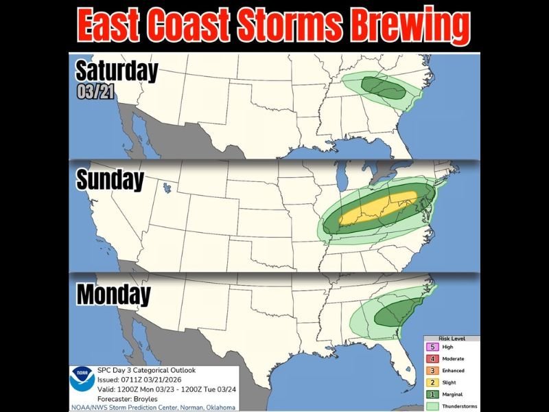
East Coast Storm System Targets North Carolina, South Carolina, Virginia and Pennsylvania With Weekend Thunderstorm Risk Into Monday
UNITED STATES — A developing storm system is set to impact large portions of the East Coast this weekend, bringing rounds of thunderstorms from the Carolinas through the Mid-Atlantic and into parts of the Northeast.
Forecasters indicate that while early activity will remain scattered, the risk will increase into Sunday before shifting along the coast into Monday.
Saturday Storms Begin Across the Carolinas and Mid-Atlantic
Storm activity is expected to begin Saturday, with scattered thunderstorms developing across parts of North Carolina, South Carolina, and extending into Virginia.
The initial setup appears relatively limited, with lower-end storm coverage and intensity. However, the presence of moisture and instability will allow for pockets of rain and isolated storms throughout the region.
These early storms will act as a precursor to a more organized system expected to develop into Sunday.
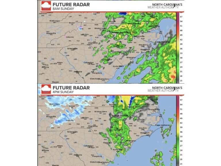
Sunday Brings Higher Storm Coverage and Stronger Risk
By Sunday, the storm system is forecast to intensify, with a broader and more organized area of thunderstorms stretching from the Southeast into the Mid-Atlantic.
The highest concentration of activity is expected across portions of North Carolina, South Carolina, Virginia, and into parts of Pennsylvania, where a stronger band of storms may develop.
This phase of the system could bring heavier rainfall, gusty winds, and a more widespread impact compared to Saturday’s scattered activity.
Storm Threat Shifts Toward the Coast on Monday
As the system progresses, the focus of storm activity will shift eastward by Monday, impacting coastal areas from the Carolinas into the Mid-Atlantic.
While the overall intensity may begin to decrease, lingering showers and thunderstorms are expected to continue, particularly along coastal regions.
This transition marks the system moving offshore, but not before delivering multiple rounds of unsettled weather to the East Coast.
Limited Rainfall Expected in Florida Midweek
Despite the broader East Coast activity, Florida is expected to see only minimal impacts from this system.
Forecasters suggest that only light showers or brief sprinkles may reach parts of the state by midweek, with little accumulation expected.
This indicates that the primary focus of the storm system will remain farther north along the Eastern Seaboard.
Multi-Day Storm Pattern Signals Active Start to Spring
The evolving weather pattern highlights a more active start to spring across the eastern United States, with multiple days of storm chances and shifting impacts.
While severe weather potential appears limited at this time, the extended nature of the system means residents should remain aware of changing conditions through the weekend and into early next week.
Forecast updates may refine the exact placement and intensity of storms as the system develops further.
If you are in the path of these storms or begin to see changing weather conditions, share your updates with us. Stay connected with SaludaStandard-Sentinel.com for ongoing coverage of this developing East Coast storm system.