Early Morning Storm Line Expected to Slam Dallas–Fort Worth Region With Hail, Damaging Winds and Rapid Temperature Drop Saturday
TEXAS — Residents across the Dallas–Fort Worth metroplex and surrounding areas could wake up to strong thunderstorms Saturday morning as a line of storms is expected to move across North Texas before sunrise.
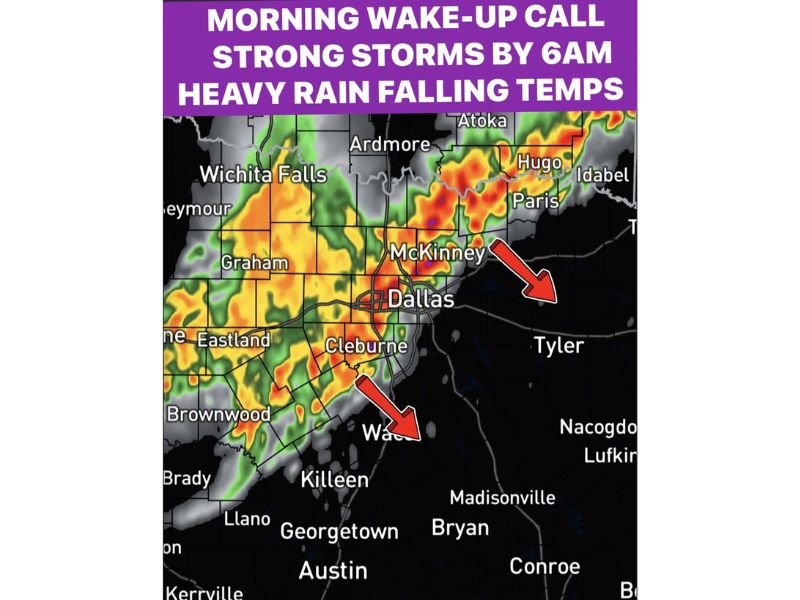
Weather models show showers and thunderstorms developing early in the morning, with storms pushing through the region around 6:00 AM Saturday. Forecasters warn that the initial wave of storms may bring hail, damaging winds, and heavy rainfall, creating potentially hazardous conditions for early morning travel.
The storms are expected to arrive as a cold front moves through the region, bringing a rapid shift in temperatures and changing weather conditions throughout the morning hours.
Storm Line Expected to Move Through the Dallas Area Before Sunrise
Forecast radar imagery indicates that a line of thunderstorms will develop west of the Dallas–Fort Worth area before moving east across the region early Saturday morning.
Cities including Dallas, McKinney, Cleburne, Graham, and Wichita Falls could experience the first round of storms as the line strengthens while moving across North Texas.
As the system pushes eastward, communities such as Paris, Hugo, and Tyler may see storms later in the morning as the line continues moving across the region.
Meteorologists say the storms will likely arrive quickly and may intensify during the early morning hours when atmospheric conditions remain favorable for thunderstorm development.
Hail and Damaging Winds Possible With Strongest Storms
Forecasters say the first storms arriving Saturday morning could produce hail and damaging wind gusts, particularly in areas directly under the strongest storm cores.
Heavy rainfall will also accompany the storms, which may reduce visibility on highways and create dangerous driving conditions during the morning commute.
Lightning is expected to be frequent within the stronger thunderstorms, posing additional risks for anyone outdoors as the storms move through the region.
Officials recommend that residents remain alert for weather warnings and allow extra travel time if storms develop during the early morning hours.
Temperatures Expected to Fall Quickly After Storms Pass
One of the most noticeable changes following the storms will be the rapid drop in temperatures across North Texas.
Before the storms arrive, temperatures across the region are expected to remain in the low 70s. However, once the cold front passes through, temperatures could quickly fall into the low to mid-50s.
Meteorologists say the combination of rain and cooler air behind the front will create a much chillier feel compared to the warm conditions experienced earlier in the week.
Rain Likely to Continue Into Saturday Afternoon
While the strongest storms are expected during the early morning hours, periods of rain may linger through much of Saturday afternoon as the weather system continues moving across the region.
Light to moderate rain could persist behind the front, keeping skies cloudy and temperatures cooler throughout the day.
Residents across the Dallas–Fort Worth region and surrounding communities are encouraged to stay weather aware as the storm system approaches and to monitor local weather alerts for any updates.
If storms impact your community Saturday morning, share your weather photos and reports with our newsroom at SaludaStandard-Sentinel.com as we continue tracking developing weather across the United States.